Homs Governorate
From Wikipedia, the free encyclopedia
For the former governorate in Libya, see Al Khums Governorate.
| Homs Governorate مُحافظة حمص | |
|---|---|
| Governorate | |
.svg.png) | |
| Coordinates (Homs): 34°18′N 38°18′E / 34.3°N 38.3°ECoordinates: 34°18′N 38°18′E / 34.3°N 38.3°E | |
| Country |
|
| Capital | Homs |
| Manatiq (Districts) | 6 |
| Area | |
| • Total | 42,223 km2 (16,302 sq mi) |
| Estimates range between 42,223 km² and 42,226 km² | |
| Population (2011) | |
| • Total | 1,803,000 |
| • Density | 43/km2 (110/sq mi) |
| Time zone | EET (UTC+2) |
| • Summer (DST) | EEST (UTC+3) |
| ISO 3166 code | SY-HO |
| Main language(s) | Arabic |
Homs Governorate (Arabic: مُحافظة حمص / ALA-LC: Muḥāfaẓat Ḥimṣ) is one of the fourteen muhafazat (governorates or provinces) of Syria. It is situated in central Syria. Its area differs in various sources, from 40,940 km².[1] to 42,223 km².[2] It is thus geographically the largest governorate of Syria. Homs Governorate has a population of 1,763,000 (2010 estimate). The Homs governorate is divided into 6 administrative districts (mantiqah). Homs is the capital city of the district of Homs.
Districts

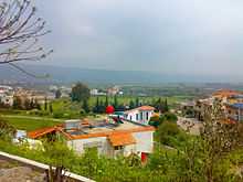
The town of Al-Huwash in Talkalakh District
The governorate is divided into 7 districts (manatiq):
The districts are further divided into 25 sub-districts (nawahi).
References
External links
- ehoms The First Complete website for Homs news and services
 |
Tartus Governorate | Hama Governorate | Ar-Raqqah Governorate |  |
| |
|
Deir ez-Zor Governorate | ||
| ||||
| | ||||
| Rif Dimashq Governorate | |
This article is issued from Wikipedia. The text is available under the Creative Commons Attribution/Share Alike; additional terms may apply for the media files.

