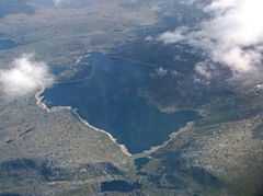
Holskardvatnet
From Wikipedia, the free encyclopedia
| Holskardvatnet | |
|---|---|
 | |
| Location | Vik (Sogn og Fjordane) |
| Coordinates | 60°56′5″N 6°10′20″E / 60.93472°N 6.17222°ECoordinates: 60°56′5″N 6°10′20″E / 60.93472°N 6.17222°E |
| Basin countries | Norway |
| Surface area | 4.81 km2 (1.86 sq mi) |
| Shore length1 | 12.19 km (7.57 mi) |
| Surface elevation | 845 m (2,772 ft) |
| References | NVE |
| 1 Shore length is not a well-defined measure. | |
Holskardvatnet is a lake in the municipality Vik in Sogn og Fjordane county, Norway. It is located just less than 100 metres (330 ft) north of the municipality (and county) border with Modalen in Hordaland county.[1] The lake is 20 kilometres (12 mi) south of the village of Ortnevik in neighboring Høyanger Municipality, about 13 kilometres (8.1 mi) southwest of the village of Arnafjord, and about 28 kilometres (17 mi) southwest of the municipal center of Vikøyri. The 4.81 square kilometres (1.86 sq mi) lake is located at an elevation of 845 metres (2,772 ft) above sea level.[2]
See also
- List of lakes in Norway
References
- ↑ "Satellite view of Holskardvatnet". Retrieved 2010-08-14.
- ↑ "Holskardvatnet" (in Norwegian). yr.no. Retrieved 2010-08-14.
This article is issued from Wikipedia. The text is available under the Creative Commons Attribution/Share Alike; additional terms may apply for the media files.