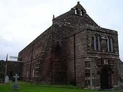
Holmcultram Abbey
 Holmcultram Abbey | |
| Monastery information | |
|---|---|
| Full name | Holmcultram Abbey |
| Order | Cistercian |
| Established | 1150 |
| Disestablished | 1538 |
| Diocese | Carlisle |
| Site | |
| Location |
Abbeytown, Cumbria, England |
| Visible remains | Nave; still used as the parish church |
| Public access | Yes |
Holmcultram Abbey (alternatively Holm Cultram Abbey or Holme Cultram Abbey) was a Cistercian monastery founded in 1150 in what is now the village of Abbeytown in Cumbria in England but at the time of foundation was in territory in the possession of David I of Scotland, who together with his son, Henry, founded it in 1150. The mother-house was Melrose Abbey, of the filiation of Cîteaux.
The community established a daughter house at Grey Abbey in Northern Ireland in 1193.
The area was re-claimed in 1157 by Henry II of England and the abbey's Scots origins did not protect it thereafter from attacks by Scots raiders, from whom it suffered repeatedly from 1216 onwards, with a particularly severe attack in 1319. It was dissolved in 1538, when the parish petitioned for, and obtained, the use of the church.
Of the monastic buildings, nothing survives. The former abbey church underwent a series of structural accidents (such as the collapse of the tower in 1600) and alterations as a result of which it gradually shrank to comprise the first six bays of the nave, without aisles. In addition the roof was lowered to the height of a single storey and there were two energetic restorations in 1883 and 1913. This nevertheless left a large enough building to continue to serve to the present day as the parish church of Abbeytown.
The church was severely damaged by arson on 9 June 2006, when original records of the monastery, including the cartulary, were destroyed.
Burials
See also
Sources
- New, Anthony, 1985: A Guide to the Abbeys of England and Wales. London: Constable ISBN 0-09-463520-X
- Robinson, David (ed.), 2002: The Cistercian Abbeys of Britain. London: B.T. Batsford ISBN 0-7134-8727-5
External links
- Pictures of the church before and after the fire
- British History Online: The Register and Records of Holm Cultram: the full text of the cartulary and other records of the abbey
- Solway Plain past and present - The Abbey
Coordinates: 54°50′43″N 3°16′58″W / 54.8454°N 3.2829°W