Hole Rock
From Wikipedia, the free encyclopedia
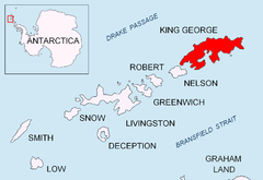
Location of King George Island in the South Shetland Islands.
Hole Rock (61°53′S 57°44′W / 61.883°S 57.733°WCoordinates: 61°53′S 57°44′W / 61.883°S 57.733°W) is the largest of several rocks lying close north of North Foreland, the northeastly cape of King George Island, in the South Shetland Islands. It was charted in 1937 by Discovery Investigations personnel on the Discovery II and so named because a conspicuous hole extends through it.[1][2]
References
- ↑ "Hole Rock". Geographic Names Information System, U.S. Geological Survey. Retrieved 2012-06-21.
- ↑ Alberts, Fred G., ed. (June 1995). Geographic Names of the Antarctic (second ed.). United States Board on Geographic Names. p. 340. Retrieved 2012-04-05.
![]() This article incorporates public domain material from the United States Geological Survey document "Hole Rock" (content from the Geographic Names Information System).
This article incorporates public domain material from the United States Geological Survey document "Hole Rock" (content from the Geographic Names Information System).
This article is issued from Wikipedia. The text is available under the Creative Commons Attribution/Share Alike; additional terms may apply for the media files.