Hohenhameln
From Wikipedia, the free encyclopedia
| Hohenhameln | ||
|---|---|---|
 | ||
| ||
 Hohenhameln | ||
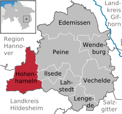
Location of Hohenhameln within Peine district 
 | ||
| Coordinates: 52°15′36″N 10°03′59″E / 52.26000°N 10.06639°ECoordinates: 52°15′36″N 10°03′59″E / 52.26000°N 10.06639°E | ||
| Country | Germany | |
| State | Lower Saxony | |
| District | Peine | |
| Government | ||
| • Mayor | Lutz Erwig (SPD) | |
| Area | ||
| • Total | 69.42 km2 (26.80 sq mi) | |
| Elevation | 101 m (331 ft) | |
| Population (2012-12-31)[1] | ||
| • Total | 9,049 | |
| • Density | 130/km2 (340/sq mi) | |
| Time zone | CET/CEST (UTC+1/+2) | |
| Postal codes | 31249 | |
| Dialling codes | 05128 | |
| Vehicle registration | PE | |
| Website | www.hohenhameln.de | |
Hohenhameln is a municipality in the district of Peine, in Lower Saxony, Germany. It is situated approximately 15 km southwest of Peine, and 25 km southeast of Hanover.
Places that belong to the Hohenhameln Community
Hohenhameln, Soßmar, Clauen, Bierbergen, Bründeln, Equord, Harber, Mehrum, Ohlum, Rötzum, Stedum
Twinnings
 Hankasalmi, Finland[2]
| Wikimedia Commons has media related to Hohenhameln. |
| |||||||
References
- ↑ Landesbetrieb für Statistik und Kommunikationstechnologie Niedersachsen, Fortgeschriebene Einwohnerzahlen zum 31. Dezember 2012
- ↑ "Deutsche Botschaft Helsinki" (in Finnish). Embassy of Germany in Finland. Retrieved 7 May 2012.
This article is issued from Wikipedia. The text is available under the Creative Commons Attribution/Share Alike; additional terms may apply for the media files.
