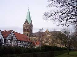
Herten
| Herten | ||
|---|---|---|
 | ||
| ||
 Herten | ||
Location of Herten within Recklinghausen district 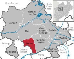
 | ||
| Coordinates: 51°36′N 7°08′E / 51.600°N 7.133°ECoordinates: 51°36′N 7°08′E / 51.600°N 7.133°E | ||
| Country | Germany | |
| State | North Rhine-Westphalia | |
| Admin. region | Münster | |
| District | Recklinghausen | |
| Subdivisions | 9 | |
| Government | ||
| • Mayor | Ulrich Paetzel (SPD) | |
| Area | ||
| • Total | 37.31 km2 (14.41 sq mi) | |
| Elevation | 75 m (246 ft) | |
| Population (2012-12-31)[1] | ||
| • Total | 61,001 | |
| • Density | 1,600/km2 (4,200/sq mi) | |
| Time zone | CET/CEST (UTC+1/+2) | |
| Postal codes | 45699, 45701 | |
| Dialling codes |
0 23 66, 02 09 (Westerholt), 0 23 65 (Marl) | |
| Vehicle registration | RE | |
| Website | www.herten.de | |

Herten is a town and a municipality in the district of Recklinghausen, in North Rhine-Westphalia, Germany. It is situated in the industrial Ruhr Area, approx. 5 km west of Recklinghausen.
It was the seat of the governors of the County of Vest Recklinghausen, an autonomous state within the Archbishopric of Cologne.
Its best known sights are the moated red brick castle Schloss Herten, dating back to the 14th century, and the "altes Dorf Westerholt" (old village of Westerholt) which consists of historic timber framing houses.
Geography
Town area
Herten has an area of 37.31 km2, with a maximal north-south extent of 9.5 km, and a maximal east-west extent of 6.5 km. The highest natural point can be found in Scherlebeck, close to the border to Recklinghausen, with an altitude of 110m.[2]
Herten has the following urban districts:
|
|
|
Neighbour towns
Herten borders on Marl in the north, Recklinghausen in the east, Herne in the south, and Gelsenkirchen in the west.
International relations
Herten is twinned with:[3]
Famous people
Born in Herten
- Ludger Pistor (born 16 March 1959), actor
- Barbara Mensing (born 23 September 1960), archer
- Christian Timm (born 27 Februar 1979), professional footballer
- Adolf Galland (19 March 1912 – 9 February 1996), German Luftwaffe General
References
- ↑ "Amtliche Bevölkerungszahlen". Landesbetrieb Information und Technik NRW (in German). 31 July 2013.
- ↑ http://www.herten.de/leben-in-herten/zahlen-daten-fakten/gemeindegebiet/index.html
- ↑ http://www.herten.de/leben-in-herten/staedtepartnerschaften-patenschaften/index.html
External links
| Wikimedia Commons has media related to Herten. |
| |||||||