Hersden
| Hersden | |
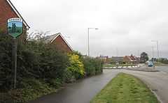
 Village entrance |
|
 Hersden | |
| Population | 6,257 [1] |
|---|---|
| OS grid reference | TR204620 |
| Civil parish | Sturry |
| District | City of Canterbury |
| Shire county | Kent |
| Region | South East |
| Country | England |
| Sovereign state | United Kingdom |
| Post town | CANTERBURY |
| Postcode district | CT3 |
| Dialling code | 01227 |
| Police | Kent |
| Fire | Kent |
| Ambulance | South East Coast |
| EU Parliament | South East England |
| UK Parliament | Canterbury |
Hersden is a village near Canterbury in Kent, South East England.
The village lies on the A28 road, an old Roman road between the City of Canterbury and the Isle of Thanet, in the civil parish of Sturry, bordering the parish of Westbere.
The village is an erstwhile coal-mining village, and the Chislet Colliery Welfare Club is located here. The pit was opened in 1890, coal having been discovered during exploration work for a channel tunnel at Shakespeare Cliff in Dover. The village grew up in the early 1900s to provide housing for the mine workforce.
A cemetery of Frisians and Jutes who were brought over by the Romans to help fight the Picts was discovered in Hersden.
Now, there is a Chinese restaurant, the village hall which houses a social club and recently a large and impressive B.M.X track was built. There are two churches in Hersden; Hersden Church (a former Anglican and Methodist which now is used as a community centre - the congregation has moved to Sturry Church) and St Dunstan, the Roman Catholic Parish church which opened in 1935.
External links
| Wikimedia Commons has media related to Hersden. |
- Chislet Colliery Welfare Club
- The Motorist Centre
- The Post Office Hersden
- Hersden Community Primary School
- Sturry Parish Council
References
- ↑ National Statistics Census 2001
