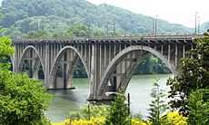
Henley Street Bridge

The Henley Bridge, or Henley Street Bridge, is a vehicle bridge that crosses the Tennessee River in Knoxville, Tennessee, United States. Completed in 1931, the 1,793-foot (547 m) bridge[1] is one of four vehicle bridges connecting Downtown Knoxville with South Knoxville, the other three being the Gay Street Bridge, the Buck Karnes Bridge, named for James Ernest Karnes, (Alcoa Highway), and the James C. Ford Memorial Bridge. The bridge carries U.S. Route 441, which is known as "Henley Street" in downtown Knoxville and "Chapman Highway" in South Knoxville.
The bridge and its associated street are named for Colonel David Henley, a Revolutionary War officer and War Department agent stationed in Knoxville in the 1790s.[2]
Design
The Henley Bridge is a reinforced concrete open-spandrel arch bridge with six dual-ribbed arches connected by lateral bracing. The lengths of the arches are (from north to south) 203 feet (62 m), 232 feet (71 m), 317 feet (97 m), 232 feet (71 m), 220 feet (67 m), and 185 feet (56 m). The deck consists of six concrete girders, and has a total width of just over 70 feet (21 m) and a curb-to-curb width of just over 54 feet (16 m).[1]
History
In the late 1920s, Knoxville developed a new city plan that called for, among other things, the widening of Henley Street and the construction of a 54-foot-wide (16 m) bridge connecting the street with South Knoxville. The city initially hired J. E. Griner and Company of Baltimore, but after the company insisted that a 36-foot width was adequate, the city rejected their design. In April 1930, after intense debate, the city selected a design submitted by the Des Moines, Iowa-based Marsh Engineering Company, which was led by long-time bridge engineer James B. Marsh (1856–1936).[1]
Throughout 1930, Knoxville's city council, various local engineers, and the Knoxville News-Sentinel argued relentlessly over the bridge, bickering with one another over everything from the bridge's size to the construction materials to be used. One councilman charged that bribery had taken place.[1] Furthermore, rather than allow Marsh Engineering to choose its own construction supervisor, the city installed local engineers L. M. Dow[3] and S. B. Goodsey as supervising engineer and resident engineer, respectively, and made numerous modifications to Marsh's design. Work finally began on September 30, 1930, with Pittsburgh contractor Booth and Flinn overseeing construction. Knoxville and Knox County split the cost of the bridge.[1]
The completion of the Henley Bridge roughly coincided with the creation of the Great Smoky Mountains National Park, and the bridge became for Knoxvillians the "gateway" to the Smokies (US-441, which crosses the bridge, is still the main route connecting Knoxville with the park).[4] Since 1987, the bridge has also been the primary fireworks launching area during Knoxville's annual Boomsday celebration.[5]
The Henley Bridge is mentioned in three novels by author Cormac McCarthy. In The Orchard Keeper (1968), a bootlegger's car breaks down on the bridge. In Suttree (1979), a homeless man known as "The Ragpicker" lives under the south end of the bridge. In The Road (2006), the Henley Bridge is the "high concrete bridge" the father and son cross near the beginning of the novel en route to the Great Smoky Mountains to the south.[6] It is also mentioned in the start of Mountain Treachery, an Amazon.com e-novel by Matt Reid.
Rehabilitation
In 2011, the Tennessee Department of Transportation began a major rehabilitation project on the bridge. The improvements called for five total lanes of vehicular traffic, two bike lanes and sidewalks, as well as improved lighting.[7][8]
The project was plagued with delays, most notably when two workers were killed in two separate incidences on the construction site. Britton Bridge LLC, the project's contractor, was fined and the construction progress was halted for two weeks by TDOT.[9] There were also several previously undetected deficiencies in the bridge's structure that lagged progress and increased cost.
The project was partially completed with the opening of two of the five lanes of traffic on October 17, 2013.[10] The final cost of the project is estimated at $32 million.[11] Contractors will finish paving work, striping and lighting improvements, with a final completion date of June 2014. [12]
References
- ↑ 1.0 1.1 1.2 1.3 1.4 Martha Carver, Tennessee's Survey Report for Historic Highway Bridges: Pre-1946 Masonry Arch, Timber Truss, Metal Truss, Concrete Arch, Metal Arch and Suspension Bridges (Nashville, Tenn.: Tennessee Department of Transportation, 2008), pp. 256, 537-538.
- ↑ Jim Matheny, "Why Do They Call It That? Henley (Street) Bridge." WBIR.com, 31 December 2010. Retrieved: 4 February 2011.
- ↑ Plaque at the Henley Bridge in Knoxville, Tennessee. Carver's report (p. 538) lists the supervising engineer's last name as "Don," although the plaque lists his name as "Dow."
- ↑ Hargreaves Associates, Knoxville South Waterfront, Tennessee – Public Improvements, 29 April 2008, p. 47. Retrieved: 15 June 2010.
- ↑ Boomsday official site. Retrieved: 15 June 2010.
- ↑ Wes Morgan, "The Route and Roots of The Road," University of Tennessee website, 2007. Retrieved: 25 April 2012.
- ↑ Hayes Hickman, Rehab for Henley Bridge Set for 2010 is Part of Statewide Upgrades. Knoxnews.com, 12 September 2009. Retrieved: 15 June 2010.
- ↑ Henley Street Bridge Rehabilitation will Include Bike Lanes. Wate.com, 11 February 2010.
- ↑ "TDOT Allows works to resume on Henley Bridge". WATE-TV. 09 June 2011. Retrieved 16 October 2013.
- ↑ WBIR Staff (16 October 2013). "Henley Bridge Reopens Wednesday". WBIR-TV. Retrieved 16 October 2013.
- ↑ "Henley Bridge construction passes completion date". WBIR-TV. 30 June 2013. Retrieved 16 October 2013.
- ↑ "Henley Bridge Update; Bridge to Open to Traffic before Thanksgiving". Tennessee Department of Transportation. Retrieved 16 October 2013.
External links
- Henley Bridge Structure, April 2004 — TDOT photographs showing some of the bridge's structural problems
- Henley Bridge Project – Citizens' Comments
Coordinates: 35°57′25″N 83°55′05″W / 35.957°N 83.918°W