Hengchun
| Hengchun 恆春 | |
|---|---|
| Urban township | |
| Hengchun Township · 恆春鎮 | |
 | |
 | |
 Hengchun | |
| Coordinates: 22°00′00″N 120°45′00″E / 22.00000°N 120.75000°E | |
| Country |
|
| Region | Southern Taiwan |
| Government | |
| • Mayor | Yeh Mingshun (葉明順) |
| Area | |
| • Total | 136.7630 km2 (52.8045 sq mi) |
| Population (August 2009) | |
| • Total | 31,123 |
| • Density | 230/km2 (590/sq mi) |
| Households | 10568 |
| Divisions | 17 villages, 272 neighborhoods |
| Postal code | 946 |
| Website | www.hengchuen.gov.tw (Chinese) |


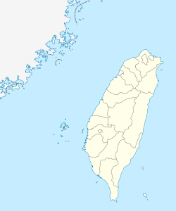
Hengchun Township (Chinese: 恆春鎮; pinyin: Héngchūn Zhèn; Pe̍h-ōe-jī: Hêng-chhun Tìn; literally "Eternal Spring Town") is an urban township located on the southern tip of the Hengchun Peninsula of Pingtung County, Taiwan. It is the southernmost township in Taiwan. Hengchun is also the only urban township in the southern part of Pingtung County. Hengchun has a land area of 136.7630 square kilometers and has a population of 31,123 as of August 2009.
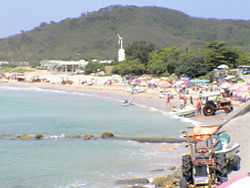
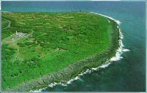
The city of Hengchun is the entry way to Kenting National Park, the southernmost National Park in the country. With pristine beaches and a vibrant tourist industry, the Hengchun area often attracts more travelers than local residents. The city itself was once completely surrounded by a city wall; now about half of the wall remains intact, as well as the four city gates. On weekends, the streets of nearby Kenting are filled with cars and tour buses. It contains the Laun Cheng Library.
The 2008 Taiwanese film Cape No. 7, the top-grossing film in Taiwan's film history, features Hengchun.
Etymology and names
"Longkiauw"
Hengchun was mostly known as "Longkiauw" before the Japanese colonization of Taiwan. Longkiauw is a name verbally translated from the Paiwanese language of the Paiwan people who lived in the area before the Han Chinese's colonization during 18th century, according to most historians it is probably the name of an ancient village located in the area which is nowadays called Hengchun but the origin of the name is still controversial.
Origin of the name "Hengchun"
According to history, after the Mudan incident which took place near the southern tip of Taiwan, Qing government official Shen Baozhen made an address to the throne for building a city in Langqiauw for foreign sailors to accommodate and protect them from the aboriginals' slaughtering. During the stay, Shen noticed that the climate of the area remained warm and sunny, with crops staying "green and wealthy" year-round, therefore he named it "恆春" ("Hengchun", literally "Eternal Spring" in English) before he left in 1894 and the term has been used to refer to the area since then.
Tourism
Hengchun is located within the Kenting National Park and is the gateway to the tropical beach resorts and night markets of downtown Kenting, therefore it is also one of the most well known tourist town in Taiwan, best known for the "Hengchun Old Town" (恆春古城). The "Hengchun Old Town" is one of the best-preserved historical towns in Taiwan with four gates intact and about half of the walls remaining. It was built during the 1st year of GuangXu's reign of the Qing dynasty in 1875 and completed in 1879. It has a north, east, south and west gate and the outer circumference of the moat measures 880 zhang (1 zhang equals 10 feet). In 1988, an actual measurement of the length was conducted, showing that the length in total amount to 2550 meters.

Climate
Hengchun is well known for its tropical monsoon climate with warm temperatures year round, the term "HengChun" literally means "Eternal Spring" in Chinese and its known for having neither a cool winter nor an extremely hot summer. The climate is generally divided into two seasons, the cooler and drier season and the warmer and wetter season. During the cool and dry season from early December to mid March of the following year, precipitation are relatively low with average daily highs reaching around 25-26°C during day time and falling to around 18-20 degrees during night time, occasional cold fronts can drop both the day and the night time temperatures by around 3°C, while daily highs during a clear day without rain can have can reach as high as 28-29°C. On the other hand, the warm and wet season, which covers the most of the year from early April to early December has daily highs usually reaching around 29-32°C during day time and night time temperatures around 24-26°C with a relatively abundant rainfall especially from May–October, when Taiwan is affected by the Pacific Typhoon Season. The climate is supportive of tropical rainforests (tropical monsoon rainforest) which inhabited the entire Hengchun peninsula, while palm trees and other tropical vegetations grows on the coastlines.
| Climate data for Hengchun (1984–2013) | |||||||||||||
|---|---|---|---|---|---|---|---|---|---|---|---|---|---|
| Month | Jan | Feb | Mar | Apr | May | Jun | Jul | Aug | Sep | Oct | Nov | Dec | Year |
| Average high °C (°F) | 24.8 (76.6) |
25.3 (77.5) |
27.4 (81.3) |
29.4 (84.9) |
31.0 (87.8) |
31.3 (88.3) |
31.9 (89.4) |
31.6 (88.9) |
31.0 (87.8) |
29.6 (85.3) |
27.6 (81.7) |
25.2 (77.4) |
28.84 (83.91) |
| Daily mean °C (°F) | 20.7 (69.3) |
21.5 (70.7) |
23.2 (73.8) |
25.2 (77.4) |
27.0 (80.6) |
28.0 (82.4) |
28.4 (83.1) |
28.1 (82.6) |
27.4 (81.3) |
26.3 (79.3) |
24.4 (75.9) |
21.8 (71.2) |
25.17 (77.3) |
| Average low °C (°F) | 18.2 (64.8) |
18.8 (65.8) |
20.2 (68.4) |
22.3 (72.1) |
24.1 (75.4) |
25.2 (77.4) |
25.6 (78.1) |
25.3 (77.5) |
24.7 (76.5) |
23.9 (75) |
22.0 (71.6) |
19.3 (66.7) |
22.5 (72.5) |
| Rainfall mm (inches) | 25.7 (1.012) |
27.7 (1.091) |
19.9 (0.783) |
43.5 (1.713) |
163.9 (6.453) |
371.3 (14.618) |
396.3 (15.602) |
475.2 (18.709) |
288.3 (11.35) |
141.8 (5.583) |
43.2 (1.701) |
20.6 (0.811) |
2,017.4 (79.425) |
| Avg. rainy days (≥ 0.1 mm) | 8.0 | 6.8 | 4.8 | 6.3 | 11.1 | 16.9 | 16.4 | 18.9 | 15.9 | 10.8 | 7.1 | 6.1 | 129.1 |
| % humidity | 72.6 | 73.7 | 74.4 | 75.4 | 78.5 | 83.6 | 83.3 | 84.0 | 79.7 | 74.0 | 70.8 | 70.7 | 76.7 |
| Mean monthly sunshine hours | 171.7 | 168.4 | 206.9 | 205.3 | 201.8 | 192.8 | 227.5 | 197.1 | 192.1 | 200.0 | 178.0 | 162.0 | 2,303.6 |
| Source: [1] | |||||||||||||
2006 Hengchun earthquake
On December 26, 2006, a 7.0–7.2 magnitude earthquake with an epicenter off the southwest coast of Taiwan occurred (approximately 22.8 km southwest of Hengchun). It caused damage to many houses in Hengchun, including fifteen historical buildings in the historic center of the township.[2] Two casualties were reported, with many more injured. It was the strongest earthquake to hit Hengchun in one hundred years.[3]
Education
Vocational High School
Middle School
Elementary Schools
- Hengchun Elementary School 屏東縣恆春鎮恆春國民小學
- Hengchun Elementary School - Nanwan Branch 屏東縣恆春鎮恆春國民小學南灣分校
- Chau Yon Elementary School 屏東縣恆春鎮僑勇國民小學
- Da Guang Elementary School 屏東縣恆春鎮大光國民小學
- Shan Hai Elementary School 屏東縣恆春鎮山海國民小學
- Swey Chuen Elementary School 屏東縣恆春鎮水泉國民小學
- Lung Chuen Elementary School 屏東縣恆春鎮龍泉國民小學
- Da Ping Elementary School 屏東縣恆春鎮大平國民小學
- Kenting Elementary School 屏東縣恆春鎮墾丁國民小學
- Er Lun Elementary School 屏東縣恆春鎮鵝鑾國民小學
See also
References
- ↑ "Statistics > Monthly Mean". Central Weather Bureau.
- ↑ 恆春古城 城倒15座, UDN, Taiwan, 2006-12-27 (Chinese)
- ↑ 2 KILLED IN STRONGEST EARTHQUAKE IN HENGCHUN IN 100 YEARS, Central News Agency, Taiwan, 2006-12-27
External links
| Wikimedia Commons has media related to Hengchun. |
| |||||||||||||||||||||
Coordinates: 22°00′N 120°45′E / 22.000°N 120.750°E
