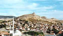
Hekimhan is a district of Malatya Province of Turkey. The mayor is Mehmet Sait Özoğlu (CHP). The district is located in Upper part of Euphrates in Eastern Anatolia. It is also located in the ancient silk road. The population of Hekimhan town and its villages has been going down since the 1980s because of closing down of iron mine establishments. Nowadays, population in the town center is 7,800. Whole polulation of the county is 25,000 while it was 52,000 in the 1970s. The people of Hekimhan are well educated and have a good sense of humor. The richness of Turkish culture and long standing traditions of centuries still live in these lovely people. They are very hospitable and open-doored. The county had rich mineral resources such as iron, chrome, dolomite, torium etc. Hekimhan once was famous for thin shelled wallnut. Famous apricots of Malatya are still widely raised in the county despite of water shortage. Hekimhan is at 1,075 meters above sea level. The highest point in Hekimhan is Zurbahan mountain (2,091 meters). Taşhan caravanserai from Seljuk Turks, a Turkish bath and a mosque from Ottomans are noticeable historical structures in the town. Hekimhan is also home to several famous politicians, singers, poets, writers, and also some mediatic figures such as Mehmet Ali Ağca.
Villages and Towns
References
|
|---|
| | Central district(s) | | |
|---|
| | Other districts | |
|---|
|
| | | Istanbul | |
|---|
| | Western Marmara | |
|---|
| | Aegean | |
|---|
| | Eastern Marmara | |
|---|
| | Western Anatolia | |
|---|
| | Mediterranean | |
|---|
| | Central Anatolia | |
|---|
| | Western Black Sea | |
|---|
| | Eastern Black Sea | |
|---|
| | North Eastern Anatolia | |
|---|
| | Central Eastern Anatolia | |
|---|
| | South Eastern Anatolia | |
|---|
| | |
|


