Hegang
| ||||||||||||||||||||||||||||||||||||||||||||||||||||||||||||||||||||||||||||||||||||||
Hegang (Chinese: 鹤岗; pinyin: Hègǎng, also known as Haoli and Heligang, is a prefecture-level city in Heilongjiang province of the People's Republic of China, situated in the southeastern section of the Lesser Khingan Range, facing Jiamusi across the Songhua River to the south and Russia's Jewish Autonomous Oblast across the Amur River to the north. Hegang is one of the principal coal-producing cities in China. Hegang covers an administrative area of 14,784 km2 (5,708 sq mi) and according to the 2010 Census, has a population of 1,058,665 inhabitants.[1] Its urban is home to 489,232 inhabitants spread out over 4 urban districts excluding Dongshan, which is still largely rural.
History
Early History
The region of Hegang was a desolate and uninhabited area until late 1890s. In 1906, the area of Hegang City was under the administration of Tangyuan County under the Qing Dynasty. Since then, the government has been encouraging people to farm in the region. In 1914, coalfield was discovered in Haoli, and Heilongjiang Government approved to set up Xinghua Mines (興華煤礦) which is jointly invested by merchants including Shen Songnian (沈松年). The area was also renamed Xingshan (興山) after the Xinghua Coal Mine. The Hegang mines were founded in 1916 by a Chinese entrepreneur with Russian capital. Hegang has witnessed rapid economic growth thanks to its rich coal resources. In 1926 a railway was built between Hegang and Jiamusi, some 30 miles to the south on the Songhua River. A coal carrier fleet was privately financed in 1930 by General Zhang Xueliang. On August 1932, Hegang mines were occupied by the Japanese as the Japanese Empire advanced through Manchuria. The mines were further developed during the Japanese occupation of Manchuria. On August 11, 1945, Hegang was occupied by the Soviet Red Army, and was relegated to the Communist Force. Since several major coal mines in southern Manchuria were controlled by Kuomintang Forces, Hegang became one of the main coal-producing area of Communist Force in the Chinese Civil-War, playing an important role in guaranteeing the acquisition of weapons and other war materials. Hegang was renamed in 1949, and set up as a prefecture-level city in Heilongjiang.[2]
People's Republic
After 1949 the city experienced further rapid growth. The mines were extended and modernized, and their annual output increased dramatically. Most of the coal is high-quality coking coal that is also used to make coal gas; apart from a small quantity consumed in Jiamusi, the bulk of it is shipped by rail to Anyang, Henan and to other industrial cities such as Anshan and Benxi in Liaoning. By the late 1950s the coal industry employed more than 80 percent of the working population. Although the mines continued to be developed and output increased, Hegang's industrial activity was beginning to diversify, especially after a large thermal-power-generating installation was constructed by the early 1970s.[3]
Geography
Hegang is located in the northeast part of Heilongjiang province, spanning from latitude 47° 04′−48° 9′ N to longitude 129° 40′−132° 31' E. Bordering prefecture-level cities are:
- Jiamusi (SE)
- Yichun (W)
The region also faces Russia's Jewish Autonomous Oblast across the Amur River with an international border of 235 kilometres (146 mi). Lesser Khingan Mountains crosses the city. The total administrative area of Hegang is 14,648 square kilometres (5,656 sq mi). Amur river and Songhua river are the main rivers in Hegang.
Climate
Hegang has a humid continental climate (Köppen Dwb/Dwa),[4] with long, bitterly cold, but dry winters, and humid and warm summers. The monthly 24-hour average temperature ranges from −17.2 °C (1 °F) in January to 21.7 °C (71.1 °F) in July, and the annual mean is 3.43 °C (38.2 °F). Close to 2/3 of the annual precipitation falls in the months of June thru August. Extreme temperatures have ranged from −34.5 to 37.7 °C.
| Climate data for Hegang (1971−2000) | |||||||||||||
|---|---|---|---|---|---|---|---|---|---|---|---|---|---|
| Month | Jan | Feb | Mar | Apr | May | Jun | Jul | Aug | Sep | Oct | Nov | Dec | Year |
| Average high °C (°F) | −12.7 (9.1) |
−7.7 (18.1) |
0.5 (32.9) |
11.1 (52) |
18.9 (66) |
23.6 (74.5) |
26.5 (79.7) |
24.7 (76.5) |
18.9 (66) |
9.9 (49.8) |
−2.1 (28.2) |
−10.9 (12.4) |
8.4 (47.1) |
| Average low °C (°F) | −20.8 (−5.4) |
−16.9 (1.6) |
−9.4 (15.1) |
0.4 (32.7) |
7.4 (45.3) |
13.7 (56.7) |
17.4 (63.3) |
15.7 (60.3) |
8.9 (48) |
0.3 (32.5) |
−10.4 (13.3) |
−18.3 (−0.9) |
−1 (30.2) |
| Precipitation mm (inches) | 3.1 (0.122) |
4.2 (0.165) |
9.2 (0.362) |
21.9 (0.862) |
55.9 (2.201) |
113.1 (4.453) |
133.9 (5.272) |
148.6 (5.85) |
75.6 (2.976) |
31.5 (1.24) |
8.8 (0.346) |
6.6 (0.26) |
612.4 (24.109) |
| Avg. precipitation days (≥ 0.1 mm) | 4.7 | 4.1 | 5.6 | 7.3 | 11.9 | 14.1 | 14.5 | 14.7 | 11.7 | 7.8 | 5.4 | 5.8 | 107.6 |
| Source: Weather China | |||||||||||||
Subdivisions
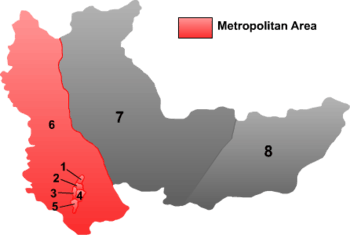
The prefecture-level city of Hegang is divided into 6 districts and 2 counties. The information presented here uses the metric system and data from the 2010 Census.
 | |||||||
| # | English Name | Simplified | Traditional | Pinyin | Area | Population | Density |
|---|---|---|---|---|---|---|---|
| 1 | Xingshan District | 兴山区 | 興山區 | Xīngshān Qū | 27 | 44,803 | 1,659 |
| 2 | Xiangyang District | 向阳区 | 向陽區 | Xiàngyáng Qū | 9 | 110,916 | 12,324 |
| 3 | Gongnong District | 工农区 | 工農區 | Gōngnóng Qū | 11 | 140,070 | 12,734 |
| 4 | Nanshan District | 南山区 | 南山區 | Nánshān Qū | 30 | 119,047 | 3,968 |
| 5 | Xing'an District | 兴安区 | 興安區 | Xīng'ān Qū | 27 | 74,396 | 2,755 |
| 6 | Dongshan District | 东山区 | 東山區 | Dōngshān Qū | 4,575 | 175,239 | 38 |
| 7 | Luobei County | 萝北县 | 蘿北縣 | Luóběi Xiàn | 6,761 | 220,131 | 33 |
| 8 | Suibin County | 绥滨县 | 綏濱縣 | Suíbīn Xiàn | 3,344 | 174,063 | 52 |
Economy
In 2010, Hegang's GDP grew 16.1% to RMB 25.1 billion, ranking tenth among 13 prefectures and prefecture-level cities in the province.[5] Agriculture and animal husbandry are considered two pillars of the city's primary industry. Heavy industry dominates the city's industrial sector. Other major industries in the city include agricultural products processing, food and beverage, pharmaceuticals, dairy and related products,forestry industries, and the production and supply of electricity.[6]
Transport
The Yichun-Hegang Highway, the Jiamusi-Hegang Highway and the Hegang-Luobei Highway form a comprehensive highway network within the city. It takes less than four hours to drive from Hegang to Harbin, the provincial capital of Heilongjiang Province. Luobei Port, which is within a one-hour drive from Hegang, is a major port on the Amur River. Jiamusi Airport, a one-hour drive from Hegang, operates flights to Beijing, Dalian and other major cities domestically.
Town twinning
![]() Birobidzhan, Jewish Autonomous Oblast, Russia
Birobidzhan, Jewish Autonomous Oblast, Russia
References
- ↑ (Chinese) Compilation by LianXin website. Data from the Sixth National Population Census of the People's Republic of China
- ↑ Hegang - China culture
- ↑ 《鹤岗市地方志》编纂委员会办公室 (1990). 鹤岗市志 History of Hegang. 黑龙江人民出版社 Heilongjiang People's Press. ISBN 978-7-207-01737-6.
- ↑ Climate map of Asia Peel, M. C., Finlayson, B. L., and McMahon, T. A.
- ↑ 2010年鹤岗市国民经济和社会发展统计公报
- ↑ Profiles of China Provinces, Cities and Industrial Parks
External links
| ||||||||||||||||||||


