Hawton
Hawton is an English civil parish of some 70 inhabitants. It is situated to the south of Newark-on-Trent in Nottinghamshire, near the River Devon.
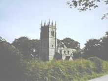
It played an important part in the English Civil War as a Roundhead encampment against the Royalist stonghold in Newark, and a redoubt earthworks are still visible within the village. It is most famed for the parish church of All Saints, built in the 14th and 15th centuries. The early 14th century saw the first building (on an earlier site) by the de Compton family. Sir Thomas Molyneux added the clerestorey and also the tower which boldly overlooks the Trent floodplain. A branch of the Molyneux family, originally from Lancashire, lived at Hawton for many centuries.[1]
Historical
Hawton was described thus:
"2 miles south-south-west of Newark, is a scattered village and parish pleasantly situated on the River Devon, comprising 227 inhabitants, and 2,150 acres (8.7 km2) of land, mostly belonging to Robert Holden Esq., of Nuthall Temple. The Duke of Newcastle and Thomas Scales have small estates here, which was soc to Newark, to which this parish adjoins, near the extensive linen manufactory called Hawton's Mills. The church, dedicated to All Saints, is in the early style of English architecture, and contains some ancient monuments of the Molyneaux family, also a few handsome marble ones to the Holdens, whose family vault is here. In 1843 the chancel was thoroughly restored, and a new roof added. The whitewash, which for many years had obscured and disgraced the rich decoration and beautiful carving was taken away. On the south side are three stone stalls, and on the north a lofty arch, having deep and rich mouldings. Beneath is the effigy of a knight in armour. The rectory, valued in the King's books at £17 13s 4d, is in the gift of Charles Newdigate Newdegate Esq. The Rev. Pelly Parker M.A. is the incumbent. The tithes have been commuted for about £750."[2]
All Saints church
See All Saints' Church, Hawton.
References
- John Quarrell, The story of Hawton Church, p.66, Newark & Sherwood District Council, 1994
Notes
External links
![]() Media related to Hawton at Wikimedia Commons
Media related to Hawton at Wikimedia Commons
Coordinates: 53°03′N 0°50′W / 53.050°N 0.833°W
