Hasloch
| Hasloch | ||
|---|---|---|
| ||
 Hasloch | ||
Location of Hasloch within Main-Spessart district 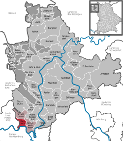 | ||
| Coordinates: 49°48′N 9°30′E / 49.800°N 9.500°ECoordinates: 49°48′N 9°30′E / 49.800°N 9.500°E | ||
| Country | Germany | |
| State | Bavaria | |
| Admin. region | Unterfranken | |
| District | Main-Spessart | |
| Municipal assoc. | Kreuzwertheim | |
| Government | ||
| • Mayor | Karl-Heinz Schöffer (SPD) | |
| Area | ||
| • Total | 10.38 km2 (4.01 sq mi) | |
| Elevation | 140 m (460 ft) | |
| Population (2012-12-31)[1] | ||
| • Total | 1,393 | |
| • Density | 130/km2 (350/sq mi) | |
| Time zone | CET/CEST (UTC+1/+2) | |
| Postal codes | 97907 | |
| Dialling codes | 09342 | |
| Vehicle registration | MSP | |
| Website | www.hasloch.de | |

Hasloch is a community in the Main-Spessart district in the Regierungsbezirk of Lower Franconia (Unterfranken) in Bavaria, Germany and a member of the Verwaltungsgemeinschaft (Administrative Community) of Kreuzwertheim.
Geography
Location
Hasloch lies in the Würzburg Region.
The community has the following Gemarkungen (traditional rural cadastral areas): Hasloch, Hasselberg.
History
In 1305, Hasloch had its first documentary mention. The former part of the Löwenstein County of Wertheim passed with a small part of the county at mediatization in 1806 to the Principality of Aschaffenburg, with which it passed in 1814 (by this time it had become a department of the Grand Duchy of Frankfurt) to Bavaria. In 1974, in the course of municipal reform, the formerly self-administering community of Hasselberg was amalgamated with Hasloch.
Population development
Within town limits, 1,502 inhabitants were counted in 1970, 1,449 in 1987 and in 2000 1,428.
Politics
The mayor is Karl-Heinz Schöffer (SPD/Freie Bürger). He succeeded Robert Stollberger (SPD/Freie Bürger) in 2002.
Municipal taxes in 1999 amounted to €853,000 (converted), of which net business taxes amounted to €214,000.
Coat of arms
The community’s arms might be described as following: Azure edged Or three hares passant in triskelion of the second, each sharing each ear with one of the others, in chief a rose argent seeded of the second, in base the same. Thus it shows the motif of the "three hares".
Sightseeing
- Eisenhammer: hammer smithy from 1779 complete with manor house
- Evangelical-Lutheran parish church
- Hexenstein im Wald (“Witch’s Stone in the Forest”, towards Faulbach)
Economy and infrastructure
According to official statistics, there were 656 workers on the social welfare contribution rolls working in producing businesses in 1998. In trade and transport this was 35. In other areas, 579 such workers worked from home. There was one processing business. No businesses were in construction, and furthermore, in 1999, there were 6 agricultural operations with a working area of 252 ha, of which 198 ha was cropland.
Education
As of 1999 the following institutions existed in Hasloch:
- Kindergartens: 75 places with 56 children
- primary school with lower grades of Hauptschule
References
- ↑ "Fortschreibung des Bevölkerungsstandes". Bayerisches Landesamt für Statistik und Datenverarbeitung (in German). 31 December 2012.
External links
| Wikimedia Commons has media related to Hasloch. |
- This article incorporates information from the German Wikipedia.