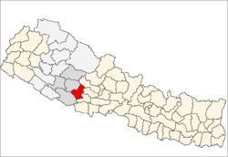
Hansapur, Rapti
From Wikipedia, the free encyclopedia
| Hansapur हंसपुर | |
|---|---|
| Village Development Committee | |
 Hansapur | |
| Coordinates: 27°56′N 82°54′E / 27.93°N 82.90°ECoordinates: 27°56′N 82°54′E / 27.93°N 82.90°E | |
| Country |
|
| Region | Mid-Western |
| Zone | Rapti Zone |
| District | Pyuthan District |
| VDC | Hansapur |
| Population (2001 Census[1]) | |
| • Total | 3,008 |
| 495 households | |
| Time zone | Nepal Time (UTC+5:45) |
Hansapur is a town and Village Development Committee in Pyuthan, a Middle Hills district of Rapti Zone, western Nepal.
Etymology
hamsa (Nepali: हंस) - soul, spirit, heart
pur (Nepali: पुर)- town or city.
Thus: town of souls
Villages in VDC
| Ward | Lat. | Lon | Elev. | ||
|---|---|---|---|---|---|
| Baguwa | बगुवा | 27°55'N | 82°55'E | 430m | |
| Baike | बैके | 27°58'N | 82°50'E | 510 | |
| Bange | बाङगे | 27°58'N | 82°52'E | 670 | |
| Bangge | बाङगे | 27°58'N | 82°53'E | 430 | |
| Beware | बेवरे | 27°58'N | 82°51'E | 610 | |
| Chabha | चाभा | 6 | 27°57'N | 82°52'E | 890 |
| Dhab | ढाब | 7 | 27°57'N | 82°51'E | 910 |
| Dumai | दुमै | 27°56'N | 82°56'E | 550 | |
| Duwakot | दुवाकोट | 27°57'N | 82°51'E | 990 | |
| Ghorlate | घोर्लटे | 27°57'N | 82°54'E | 690 | |
| Gotheri | गोठेरी | 27°56'N | 82°54'E | 810 | |
| Gurungdanda | गुरुङडाँडा | 27°57'N | 82°51'E | 1,043 | |
| Hansapur | हंसपुर | 1 | 27°56'N | 82°54'E | 810 |
| Jabune | जाबुने | 27°55'N | 82°55'E | 410 | |
| Kaskot | कासकोट | 27°57'N | 82°53'E | 930 | |
| Khewarepani | केवरेपानी | 27°58'N | 82°50'E | 870 | |
| Machhedi | मछेडी | 27°57'N | 82°55'E | 410 | |
| Odale | ओदाले | 27°58'N | 82°53'E | 490 | |
| Okhardanda | ओखरडाँडा | 27°57'N | 82°51'E | 870 | |
| Panaha | पनाहा | 27°58'N | 82°52'E | 430 | |
| Sajekot | सजेकोट | 4 | 27°57'N | 82°53'E | 950 |
| Sujanpur | सुजनपुर | 5 | 27°57'N | 82°53'E | 690 |
| Udin dhungga | उदिन ढुङगा | 27°57'N | 82°52'E | 950 | |
References
- ↑ "Nepal Census 2001". Nepal's Village Development Committees. Digital Himalaya. Retrieved 21 September 2008.
- ↑ "Index of Geographical Names of Nepal, Volume IV: Mid Western Development Region, List of Settlements, Pyuthan". Government of Nepal, National Geographic Information Infrastructure Program. Retrieved 2011-03-12.
External links
| |||||||||||
This article is issued from Wikipedia. The text is available under the Creative Commons Attribution/Share Alike; additional terms may apply for the media files.
