Halsall
| Halsall | |
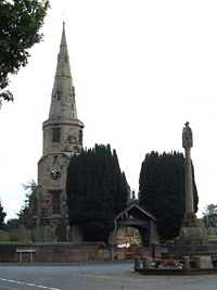
 St Cuthbert's Church, with Halsall war memorial to the right |
|
 Halsall | |
| Civil parish | Halsall |
|---|---|
| District | West Lancashire |
| Shire county | Lancashire |
| Region | North West |
| Country | England |
| Sovereign state | United Kingdom |
| Post town | ORMSKIRK |
| Postcode district | L39 |
| Dialling code | 01704 |
| Police | Lancashire |
| Fire | Lancashire |
| Ambulance | North West |
| EU Parliament | North West England |
| UK Parliament | West Lancashire |
| |

Halsall is a village and civil parish in West Lancashire, England, located close to Ormskirk on the A5147 and Leeds and Liverpool Canal. The parish has a population of 1,921 and covers an area of 28.31 square kilometres. The church and much of the village stand on a rocky ridge, in marked contrast to the low-lying flat peat mossland between the ridge and the sand of Ainsdale and Birkdale.
In Halsall there is one church dedicated to St. Cuthbert, which dates from the 14th century, the Rector is the Rev. Paul Robinson. There is a junior school, St Cuthbert's Church of England Primary School with around 140 pupils from age 4 to 11. The Saracen's Head is a large public house on the banks of the canal. There is also a post office, a garage, a financial adviser office (in what used to be the Scarisbrick Arms public house) and a phone box. Halsall now has a pharmacy, situated by the playing fields. The central feature in the village is the war memorial located in front of the church on what is now a traffic island.
Halsall is where the first sod was ceremonially dug (on 5 November 1770, by the Hon. Charles Mordaunt of Halsall Hall) for the commencement of the Leeds and Liverpool Canal, and a sculpture ("Halsall Navvy" by Thompson Dagnall) just across the bridge from the Saracen's Head pub now commemorates this. Halsall Hall still stands, but it is now divided into several houses.
Halsall built up from being a small farming settlement, and, reflecting this background,much of the land area of Halsall is sparsely populated with many isolated dwellings. The land area (and postal area) of Halsall extends quite a way towards Ainsdale along Carr Moss Lane, to a point where the border is closer to Ainsdale village centre than it is to Halsall.
The village has two bus stops, served by the 300 bus route, operated by Arriva, travelling from Liverpool to Southport (and the reverse) and the 315 operated by Holmeswood Coaches, running between Southport and Ormskirk. Halsall railway station on the Liverpool, Southport and Preston Junction Railway was in service between 1887 and 1938.
External links
| Wikimedia Commons has media related to Halsall. |