Haimhausen
From Wikipedia, the free encyclopedia
| Haimhausen | ||
|---|---|---|
| ||
 Haimhausen | ||
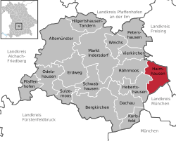
Location of Haimhausen within Dachau district  | ||
| Coordinates: 48°19′N 11°34′E / 48.317°N 11.567°ECoordinates: 48°19′N 11°34′E / 48.317°N 11.567°E | ||
| Country | Germany | |
| State | Bavaria | |
| Admin. region | Oberbayern | |
| District | Dachau | |
| Subdivisions | 8 Ortsteile | |
| Government | ||
| • Mayor | Peter Felbermeier (CSU) | |
| Area | ||
| • Total | 26.73 km2 (10.32 sq mi) | |
| Elevation | 487 m (1,598 ft) | |
| Population (2012-12-31)[1] | ||
| • Total | 5,029 | |
| • Density | 190/km2 (490/sq mi) | |
| Time zone | CET/CEST (UTC+1/+2) | |
| Postal codes | 85778 | |
| Dialling codes | 08133 | |
| Vehicle registration | DAH | |
| Website | www.haimhausen.net | |
Haimhausen is a municipality in the district of Dachau in Bavaria, Germany, just north of Munich. It has a few shops, including a post office, flower shop, butchers, bakery, shoe shop, wine shop and Supermarket, as well as a stately home, which is now home to the Bavarian International School. There is a Shell petrol station. It has its own motorway exit on the A99. Haimhausen also has an adventure playground, and a skatepark.
Objects of interest
- Description of the Schlosskapelle
- Description of the church St.Martin in Amperpettenbach
- Description of the church St.Peter und Paul in Westerndorf
- Description of the Stidlkapelle in Oberndorf
References
- ↑ "Fortschreibung des Bevölkerungsstandes". Bayerisches Landesamt für Statistik und Datenverarbeitung (in German). 31 December 2012.
- This article incorporates information from the German Wikipedia.
| |||||||
This article is issued from Wikipedia. The text is available under the Creative Commons Attribution/Share Alike; additional terms may apply for the media files.
