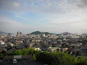
Hōfu, Yamaguchi
From Wikipedia, the free encyclopedia
| Hōfu 防府市 | ||
|---|---|---|
| City | ||
 | ||
| ||
 | ||
 Hōfu | ||
| Coordinates: 34°3′N 131°34′E / 34.050°N 131.567°ECoordinates: 34°3′N 131°34′E / 34.050°N 131.567°E | ||
| Country | Japan | |
| Region | Chūgoku (San'yō) | |
| Prefecture | Yamaguchi Prefecture | |
| Government | ||
| • Mayor | Masato Matsuura | |
| Area | ||
| • Total | 188.59 km2 (72.82 sq mi) | |
| Population (May 2008) | ||
| • Total | 117,535 | |
| • Density | 623/km2 (1,610/sq mi) | |
| Time zone | Japan Standard Time (UTC+9) | |
| Symbols | ||
| - Tree | Sangoju (Viburnum odoratissimum var. awabuki) | |
| - Flower | Scarlet Sage | |
| - Flowering tree | Ume | |
| Address |
7-1, Kotobukichō, Hōfu-shi, Yamaguchi-ken 747-8501 | |
| Phone number | 0835-23-2111 | |
| Website | Hōfu City | |
Hōfu (防府市 Hōfu-shi) is a city located in Yamaguchi Prefecture, Japan.
As of 2008, the city has an estimated population of 117,535 and a population density of 623 of persons per km². The total area is 188.59 km².
History
Hōfu (防府) means "the capital (国府) of Suō Province (周防国)". The eastern part of Yamaguchi Prefecture was formerly called Suō Province.
The city was founded on August 25, 1936.[1] The city's change during the past fifty years can be visualised in the animated film Mai Mai Miracle, with its story taking place in the year of 1955 (with flashbacks a 1,000 years further back).[2]
Mazda maintains a large automobile factory in Hōfu.[3]
Education
- Yamaguchi Junior College (private junior college)
Main sightseeing spots
Sister Cities
-
 Akitakata, Hiroshima, Japan since July 16, 1971[4]
 -
 Chuncheon, Gangwon-do, South Korea since October 29, 1991[5]
 -
 Monroe, Michigan, United States, since May 29, 1993[6]
Famous People
- Taneda Santōka
References
- ↑ "市の概要・市章(Japanese)".
- ↑ Stills from the film juxtaposed with modern photos(Japanese)
- ↑ "Offices." Mazda. Retrieved on October 29, 2009.
- ↑ "防府市の姉妹都市(安芸高田市)(Japanese)".
- ↑ "防府市の姉妹都市(春川市・冬のソナタのロケ地)(Japanese)".
- ↑ http://www.ci.monroe.mi.us/Hofu_Mayor_Visit.cfm Twin towning with Monroe, Michigan
External links
| Wikimedia Commons has media related to Hofu, Yamaguchi. |
- Hōfu City official website (Japanese)
- Hōfu City official website (English)
- Oidemase Hōfu website (Japanese)
| |||||||||||||||||||
This article is issued from Wikipedia. The text is available under the Creative Commons Attribution/Share Alike; additional terms may apply for the media files.
