Hünstetten
| Hünstetten | ||
|---|---|---|
| ||
 Hünstetten | ||
Location of Hünstetten within Rheingau-Taunus-Kreis district 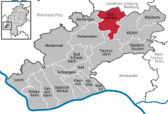
 | ||
| Coordinates: 50°13′N 8°10′E / 50.217°N 8.167°ECoordinates: 50°13′N 8°10′E / 50.217°N 8.167°E | ||
| Country | Germany | |
| State | Hesse | |
| Admin. region | Darmstadt | |
| District | Rheingau-Taunus-Kreis | |
| Government | ||
| • Mayor | Axel Petri | |
| Area | ||
| • Total | 50.56 km2 (19.52 sq mi) | |
| Elevation | 360 m (1,180 ft) | |
| Population (2012-12-31)[1] | ||
| • Total | 10,168 | |
| • Density | 200/km2 (520/sq mi) | |
| Time zone | CET/CEST (UTC+1/+2) | |
| Postal codes | 65510 | |
| Dialling codes | 06126, 06128, 06438 | |
| Vehicle registration | RÜD | |
| Website | www.gemeinde-huenstetten.de | |
Hünstetten is a community in the Rheingau-Taunus-Kreis in the Regierungsbezirk of Darmstadt in Hesse, Germany.
Geography
Location
Hünstetten lies in the Taunus north of the main ridge between Limburg and the state capital Wiesbaden.
Neighbouring communities
Hünstetten borders in the north on the community of Hünfelden, in the northeast on the town of Bad Camberg (both in Limburg-Weilburg), in the east on the town of Idstein, in the south on the town of Taunusstein and in the west on the communities of Hohenstein and Aarbergen (all in the Rheingau-Taunus-Kreis).
Constituent communities
Hünstetten is made up of the following Ortsteile:
| Constituent community | Inhabitants | |
|---|---|---|
| |
Bechtheim | 937 |
| |
Beuerbach | 1,176 |
| |
Görsroth | 1,248 |
| |
Kesselbach | 778 |
| |
Ketternschwalbach | 489 |
| |
Limbach | 751 |
| |
Oberlibbach | 619 |
| |
Strinz-Trinitatis | 1,026 |
| |
Wallbach (Taunus) | 1,068 |
| |
Wallrabenstein | 2,126 |
Total: 10,218
The population figures are based on data for 31 December 2007.
History
In the course of municipal reform in Hesse, the community of Hünstetten came into being on 1 January 1972 through the merger of the communities of Beuerbach, Kesselbach, Ketternschwalbach, Limbach, Strinz-Trinitatis and Wallbach. On 1 July 1972, they were joined by Oberlibbach, and then Bechtheim, Görsroth and Wallrabenstein on 1 January 1977, giving Hünstetten its current shape.
Politics
Community council
The municipal election held on 26 March 2006 yielded the following results:
| Parties and voter communities | % 2006 |
Seats 2006 |
% 2001 |
Seats 2001 | |
| CDU | Christian Democratic Union of Germany | 35.5 | 10 | 31.4 | 10 |
| SPD | Social Democratic Party of Germany | 50.7 | 14 | 56.6 | 17 |
| independent | 3 | ||||
| GREENS | Bündnis 90/Die Grünen | 10.4 | 3 | 9.4 | 3 |
| FDP | Free Democratic Party | 3.4 | 1 | 2.6 | 1 |
| Total | 100.0 | 31 | 100.0 | 31 | |
| Voter turnout in % | 58.1 | 59.8 | |||
Coat of arms

The community’s arms might be described thus: Or a side sinister and dexter and a fess joining them between the fess point and the honour point, the whole gules with the fess between ten dolmens azure, four of which in chief.
The German blazon says that the dolmens (called Doppel-T-Kopfschäfte, although it is explained that they are meant to be dolmens) should be blue, despite their silvery appearance here.
The coat of arms was approved in December 1979 by the State Archive in Darmstadt, and was given its form by Bad Nauheim heraldic artist Heinz Ritt after the community’s guidelines. The ten dolmens symbolize the ten formerly self-administering communities, and the sides (stripes down each side) and the fess (horizontal stripe) form a red uppercase H, the new (in 1972) greater community’s initial letter. The H’s crossbar also stands for the Hühnerstraße (road), which splits the community into four constituent communities on one side and six on the other.
Town partnerships
 Neukirchen am Großvenediger, Salzburg, Austria since 1976
Economy and infrastructure
The community was once rural, and agriculture still plays a rôle in Hünstetten’s livelihood today. All in all, though, it changed over the latter half of the 20th century into a residential community. There are some 800 jobs in town, meaning that the overwhelming majority of the workforce earns its livelihood outside the community, with the good road links ensuring that this means mainly in the Frankfurt Rhine Main Region.
Transport
The community is well linked to the long-distance road network through the Bad Camberg (4 km away) and Idstein (8 km away) interchanges on the A 3. Furthermore, Bundesstraße 417 runs through the greater community. Wiesbaden lies 22 km away, Mainz 26 km and Frankfurt 50 km.
Education
- IGS Wallrabenstein (integrated comprehensive school) in Wallrabenstein
- Rabenschule (primary school) in Wallrabenstein
- Panoramaschule (primary school) in Görsroth
References
- ↑ "Die Bevölkerung der hessischen Gemeinden". Hessisches Statistisches Landesamt (in German). July 2013.
- This article incorporates information from the German Wikipedia.
| |||||||