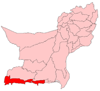
Gwadar District
| ضِلع گوادر | |
|---|---|
| District | |
| Gwadar District | |
 | |
| Country | Pakistan |
| Province | Balochistan |
| Capital | Gwadar |
| Established | 1 July 1977 |
| Government | |
| • District Nazim | Mir Abdul Ghafoor |
| • District Naib Nazim | Abdul Ghaffar Hoth |
| Area | |
| • Total | 15,216 km2 (5,875 sq mi) |
| Population (1998) | |
| • Total | 178,989 |
| • Density | 16.4/km2 (42/sq mi) |
| Time zone | PST (UTC+5) |
| Number of Tehsils | 3 |
| Website | gwadar.sdnpk.org |
Gwadar District (Balochi: ضِلع گوادر), is a District of Pakistan, and coastal region on the Arabian Sea, in Balochistan Province of southwestern Pakistan. The City of Gwadar is the district headquarters of Gwadar District.
Administration
Gwadar District is subdivided into five Tehsils or sub—districts:
Geography and natural history
Gwadar District has a 600 kilometres (370 mi) long coastline along the Gulf of Oman of the Arabian Sea. It consists mostly of lands and hills with sparse desert habitats. The exception are the riparian habitats along the Dasht River. It flows south through the district, from northern headwaters in Mirani Dam of the Kech District, to its river mouth at the Arabian Sea.
Demography
According to the 1998 census, the population of Gwadar District was 178,989 people.[1] It is 12,637 km² in area, with a population density of 15 people/km².
References
- ↑ "Gwadar District". Archived from the original on 2008-10-06.
External links
| Wikimedia Commons has media related to Gwadar District. |
| ||||||||||
Coordinates: 25°20′N 63°20′E / 25.333°N 63.333°E