Gundelsheim, Baden-Württemberg
From Wikipedia, the free encyclopedia
| Gundelsheim | ||
|---|---|---|
 | ||
| ||
 Gundelsheim | ||
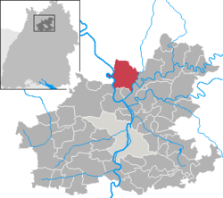
Location of Gundelsheim within Heilbronn district  | ||
| Coordinates: 49°17′N 9°10′E / 49.283°N 9.167°ECoordinates: 49°17′N 9°10′E / 49.283°N 9.167°E | ||
| Country | Germany | |
| State | Baden-Württemberg | |
| Admin. region | Stuttgart | |
| District | Heilbronn | |
| Subdivisions | 7 | |
| Government | ||
| • Mayor | Heike Schokatz | |
| Area | ||
| • Total | 38.45 km2 (14.85 sq mi) | |
| Elevation | 154 m (505 ft) | |
| Population (2012-12-31)[1] | ||
| • Total | 7,129 | |
| • Density | 190/km2 (480/sq mi) | |
| Time zone | CET/CEST (UTC+1/+2) | |
| Postal codes | 74831 | |
| Dialling codes | 06269, 06265 (Bernbrunn), 07136 (Höchstberg, Obergriesheim) | |
| Vehicle registration | HN | |
| Website | www.gundelsheim.de | |
Gundelsheim is a town in the district of Heilbronn in Baden-Württemberg in southern Germany.
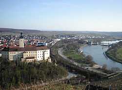
It is situated on the right bank of the Neckar, 17 km northwest of Heilbronn. The town centre retains its narrow mediaeval street plan, as well as much of its mediaeval timber architecture. Pickled gherkin manufacture and wine-growing are the two principal agricultural products, and the Neckarsulm-Gundelsheim Weingärtnergenossenschaft (vintner's co-operative) is reputed to be the oldest in all of Germany.
The most remarkable building in Gundelsheim is Castle Horneck, a former residence of the Teutonic order, now hosting the Transylvanian Museum.
References
- ↑ [Statistisches Bundesamt – Gemeinden in Deutschland mit Bevölkerung am 31.12.2012 (XLS-Datei; 4,0 MB) (Einwohnerzahlen auf Grundlage des Zensus 2011) "Gemeinden in Deutschland mit Bevölkerung am 31.12.2012"]. Statistisches Bundesamt (in German). 12 November 2013.
Notes
- This article incorporates information from the German Wikipedia.
This article is issued from Wikipedia. The text is available under the Creative Commons Attribution/Share Alike; additional terms may apply for the media files.
