Grumello del Monte
From Wikipedia, the free encyclopedia
| Grumello del Monte | ||
|---|---|---|
| Comune | ||
| Comune di Grumello del Monte | ||
 | ||
| ||
 Grumello del Monte | ||
| Coordinates: 45°38′N 9°52′E / 45.633°N 9.867°ECoordinates: 45°38′N 9°52′E / 45.633°N 9.867°E | ||
| Country | Italy | |
| Region | Lombardy | |
| Province | Bergamo (BG) | |
| Frazioni | San Pantaleone, Boldesico | |
| Government | ||
| • Mayor | Giuliano Lanzini | |
| Area | ||
| • Total | 9.8 km2 (3.8 sq mi) | |
| Elevation | 208 m (682 ft) | |
| Population (Dec. 2004)[1] | ||
| • Total | 6,619 | |
| • Density | 680/km2 (1,700/sq mi) | |
| Demonym | Grumellesi | |
| Time zone | CET (UTC+1) | |
| • Summer (DST) | CEST (UTC+2) | |
| Postal code | 24064 | |
| Dialing code | 035 | |
| Patron saint | Holy Trinity | |
| Saint day | June 20 | |

Grumello del Monte is a comune (municipality) of c. 6,000 inhabitants in the province of Bergamo in the Italian region of Lombardy, located about 60 km northeast of Milan and about 15 km southeast of Bergamo.
Grumello del Monte borders the following municipalities: Carobbio degli Angeli, Castelli Calepio, Chiuduno, Gandosso, Palazzolo sull'Oglio, Telgate.
History
The village's origins date from the Roman domination, as attested by the name, deriving from Latin grumus (hill). The castle was probably built in the 10th century AD.
Main sights
- The medieval castle, turned into a residence by Bartolomeo Colleoni in the 14th century.
- Parish church (1720).
- Sanctuary of the Madonna del Buon Consiglio (15th century)
- Church of San Pantaleone.
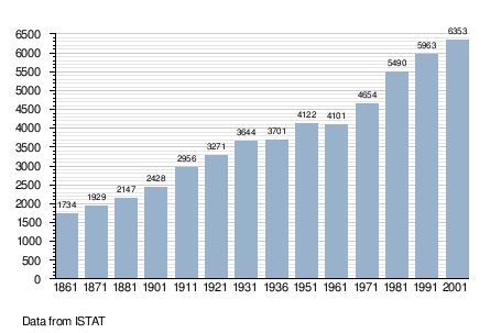
Demographic evolution
References
This article is issued from Wikipedia. The text is available under the Creative Commons Attribution/Share Alike; additional terms may apply for the media files.