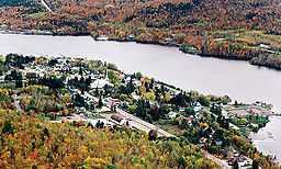
Grandes-Piles, Quebec
| Grandes-Piles | |
|---|---|
| Village municipality | |
 | |
 | |
 Grandes-Piles | |
| Coordinates: 46°41′N 72°44′W / 46.683°N 72.733°WCoordinates: 46°41′N 72°44′W / 46.683°N 72.733°W[1] | |
| Country |
|
| Province |
|
| Region | Mauricie |
| RCM | Mékinac |
| Settled | c. 1850 |
| Constituted | August 10, 1885 |
| Government[2] | |
| • Mayor | Jean-Pierre Ratelle |
| • Federal riding | Saint-Maurice—Champlain |
| • Prov. riding | Laviolette |
| Area[2][3] | |
| • Total | 124.80 km2 (48.19 sq mi) |
| • Land | 120.66 km2 (46.59 sq mi) |
| Population (2011)[3] | |
| • Total | 361 |
| • Density | 3.0/km2 (8/sq mi) |
| • Pop 2006-2011 |
|
| • Dwellings | 234 |
| Time zone | EST (UTC−5) |
| • Summer (DST) | EDT (UTC−4) |
| Postal code(s) | G0X 1H0 |
| Area code(s) | 819 |
| Highways |
|
| Census profile | 2435040[3] |
| MAMROT info | 35040[2] |
| Toponymie info | 228457[1] |
| Website | www.grandespiles.qc.ca |
Grandes-Piles is a village municipality in the Mauricie region of the province of Quebec in Canada.
This small village is located on a cliff of the Saint-Maurice River north of Grand-Mère. As the birthplace of the log drives in the Mauricie, it has an interpretive centre of the forest industry. The reopening of the river for recreational boating made it a favorite spot for water sports and sailing. In winter, the frozen river and snowy cliffs become a vast area for winter sports.
The name of Grandes-Piles (literally "large piles") has uncertain origin. One of the best-known but false explanations is that it referred to a stack of logs entanglement on the rocks of the Saint-Maurice that inspired the early settlers. Another explanation claims that it referred to the large rocks used by the indigenous Americans to grind grain. It may also refer to the stack of stratums, horizontal sedimentary layers that are exposed in this part of the Mauricie.[1]
It is twinned with the city of Clamecy, Nièvre in France since 1996.
History
The first settlers of Grandes-Piles arrived circa 1850 and were drawn to the area because of the large stands of white and red pine. In 1852, the Norcross & Philips Company obtained the logging rights there. From 1852 to 1855, the Saint-Maurice River from La Tuque to Trois-Rivières was dredged and prepared for log driving, and Grandes-Piles became the gateway to lumberjacks and log drivers. In 1878, the village's first sawmill was built, followed by an industrial boom which led to the construction of a railway between Trois-Rivières and Grandes-Piles.[4]
In 1882, the post office opened. In 1885, the village was incorporated as the Parish Municipality of Saint-Jacques-des-Piles, named in honour of Jacques Buteux. At that time, it was the main transportation hub for the interior areas of the Mauricie since it was located at the head of navigation on the Saint-Maurice, and had warehouses and rail access. In 1890, 14 coal furnaces were installed and iron was produced in the town until 1920. In 1925, the road to Saint-Jacques-des-Piles was built.[1][4]
In 1966, Saint-Jacques-des-Piles was renamed to Grandes-Piles, and in 1988, it changed its status to Village Municipality. In 1997, the Compagnie de flottage du St-Maurice, the company responsible for log driving on the Saint-Maurice, ceased operations and the industrial waterfront of Grandes-Piles was reclaimed for tourism.[1][4]
Boundaries
Archange Lake is on the border of Grandes-Piles and Sainte-Thècle.
Demographics
| Year | Population | Variation (%) | Median age |
|---|---|---|---|
| 2011 | 361 | | 52,2 ans |
| 2006 | 350 | | – |
| 2001 | 374 | | – |
| 1996 | 371 | | – |
| 1991 | 363 | – | – |
| 1986 | – | – |
Private dwellings occupied by usual residents: 186 (total dwellings: 234)
Mother tongue:[7]
- English as first language: 1,4 %
- French as first language: 97,2%
- English and French as first language: 0%
- Other as first language: 1,4 %
Pictures of Grandes-Piles
References
- ↑ 1.0 1.1 1.2 1.3 1.4 Reference number 228457 of the Commission de toponymie du Québec (French)
- ↑ 2.0 2.1 2.2 Geographic code 35040 in the official Répertoire des municipalités (French)
- ↑ 3.0 3.1 3.2 "(Code 2435040) Census Profile". 2011 census. Statistics Canada. 2012.
- ↑ 4.0 4.1 4.2 "Histoire de Grandes-Piles" (in French). Village de Grandes-Piles. Retrieved 2010-03-01.
- ↑ Statistics Canada: 1996, 2001, 2006, 2011 census
- ↑ Institut de la statistique du Québec
- ↑ "(Code 2435040) Census Profile". 2011 census. Statistics Canada. 2012.
| Wikimedia Commons has media related to Grandes-Piles, Québec. |
 |
Saint-Roch-de-Mékinac | Sainte-Thècle |  | |
| |
Saint-Tite | |||
| ||||
| | ||||
| Shawinigan | Hérouxville |
| ||||||||||||||||||||

