Gründau
From Wikipedia, the free encyclopedia
| Gründau | ||
|---|---|---|
| ||
 Gründau | ||
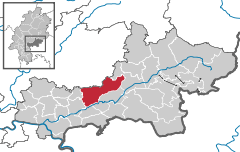
Location of Gründau within Main-Kinzig-Kreis district 
 | ||
| Coordinates: 50°13′N 09°09′E / 50.217°N 9.150°ECoordinates: 50°13′N 09°09′E / 50.217°N 9.150°E | ||
| Country | Germany | |
| State | Hesse | |
| Admin. region | Darmstadt | |
| District | Main-Kinzig-Kreis | |
| Subdivisions | 7 districts | |
| Government | ||
| • Mayor | Heiko Merz (SPD) | |
| Area | ||
| • Total | 67.64 km2 (26.12 sq mi) | |
| Elevation | 135 m (443 ft) | |
| Population (2012-12-31)[1] | ||
| • Total | 14,394 | |
| • Density | 210/km2 (550/sq mi) | |
| Time zone | CET/CEST (UTC+1/+2) | |
| Postal codes | 63584 | |
| Dialling codes |
06058, 06051 (Lieblos / Rothenbergen) | |
| Vehicle registration | MKK | |
| Website | www.gruendau.de | |
Gründau is a municipality in the district Main-Kinzig, in Hessen, Germany.
Geography
Neighbouring places
Gründau is located near Gelnhausen and Büdingen. Frankfurt am Main, the largest city in Hessen, is located in a distance of about 50 km.
Division of the municipality
Gründau is a municipality that consists of seven villages, with a population of 14,670 in total (population as of June 2009)
- Lieblos (3,727, population as of June 2008)
- Rothenbergen (3,797, population as of June 2008)
- Niedergründau (1,785, population as of June 2008)
- Mittel-Gründau (2,103, population as of June 2008)
- Hain-Gründau (1,746, population as of June 2008)
- Breitenborn (1,144; population as of June 2008)
- Gettenbach (430, population as of June 2008)
History
Most of the villages are mentioned in church registers since 11th century.
Religious affiliation
54.1% Protestants, 18.9% Catholics, 27% other faiths
Twin towns
- Laussonne, Département Haute-Loire (43), Auvergne, France
- Neugersdorf, Saxony (Sachsen), Germany
References
- ↑ "Die Bevölkerung der hessischen Gemeinden". Hessisches Statistisches Landesamt (in German). July 2013.
External links
- Official site (German)
This article is issued from Wikipedia. The text is available under the Creative Commons Attribution/Share Alike; additional terms may apply for the media files.
