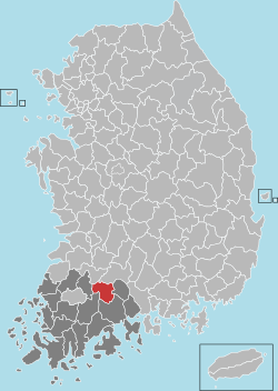
Gokseong County
From Wikipedia, the free encyclopedia
| Gokseong 곡성 | ||
|---|---|---|
| County | ||
| Korean transcription(s) | ||
| • Hangul | 곡성군 | |
| • Hanja | 谷城郡 | |
| • Revised Romanization | Gokseong-gun | |
| • McCune-Reischauer | Koksŏng-gun | |
| ||
 | ||
| Country |
| |
| Region | Honam | |
| Administrative divisions | 1 eup, 10 myeon | |
| Area | ||
| • Total | 547.37 km2 (211.34 sq mi) | |
| Population (2001) | ||
| • Total | 37,080 | |
| • Density | 67.7/km2 (175/sq mi) | |
| • Dialect | Jeolla | |
Gokseong County (Gokseong-gun) is a county in South Jeolla Province, South Korea.
Attractions
- Taeansa Temple[1]
- Neungpa Tower
- Dongli mountain valley
- Gok-song Haneulnari Village (a farming-themed village)
Transportation
Train
Jeolla Line comes into Gokseong station. The Saemaul and Mugunghwa trains all stop on the way to Gokseong.
Bus
Buses to Gwangju and Gurye take 30 minutes and to Namwon takes one hour. However, it is quite difficult to go to southern parts of Jeollas like Suncheon, Jeonnam.
Car
There are 3 interchanges on the Honam Expressway. These interactions are joined with other roads.
Twin towns – Sister cities
Gokseong is twinned with:
-
 Gangdong-gu, South Korea (1996)
 -
 Geochang, South Korea (1998)
 -
 Seo-gu, South Korea (2000)
 -
 Uijeongbu, South Korea (2010)
References
- ↑ Cin Woo Lee "Simply stunning: 33 incredible Korean temples" CNN Go. 10 February 2012. Retrieved 2012-04-12
External links
| ||||||||||||||
Coordinates: 35°16′51″N 127°17′43″E / 35.2808333433°N 127.295277788°E
This article is issued from Wikipedia. The text is available under the Creative Commons Attribution/Share Alike; additional terms may apply for the media files.

