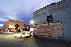
Glenwood, Arkansas
| Glenwood, Arkansas | |
|---|---|
| City | |
 | |
 | |
| Coordinates: 34°19′41″N 93°32′54″W / 34.32806°N 93.54833°WCoordinates: 34°19′41″N 93°32′54″W / 34.32806°N 93.54833°W | |
| Country | United States |
| State | Arkansas |
| Counties | Pike, Montgomery |
| Area | |
| • Total | 6.0 sq mi (15.5 km2) |
| • Land | 5.64 sq mi (14.6 km2) |
| • Water | .36 sq mi (0.9 km2) |
| Elevation | 561 ft (171 m) |
| Population (2000) | |
| • Total | 1,751 |
| • Density | 625.4/sq mi (243.2/km2) |
| Time zone | Central (CST) (UTC-6) |
| • Summer (DST) | CDT (UTC-5) |
| ZIP code | 71943 |
| Area code(s) | 870 |
| FIPS code | 05-27310 |
| GNIS feature ID | 0077028 |
Glenwood is a city in Pike and Montgomery counties in the U.S. state of Arkansas. The population was 1,751 at the 2000 census.
Geography
Glenwood is located at 34°19′41″N 93°32′54″W / 34.32806°N 93.54833°W (34.328029, -93.548412)[1].
According to the United States Census Bureau, the city has a total area of 6.0 square miles (16 km2), of which, 5.64 square miles (14.6 km2) of it is land and 0.36% is water.
Demographics
As of the census[2] of 2000, there were 1,751 people, 696 households, and 446 families residing in the city. The population density was 630.5 people per square mile (243.2/km²). There were 772 housing units at an average density of 278.0/sq mi (107.2/km²). The racial makeup of the city was 88.18% White, 1.03% Black or African American, 1.03% Native American, 0.17% Asian, 8.79% from other races, and 0.80% from two or more races. 11.31% of the population were Hispanic or Latino of any race.
There were 696 households out of which 29.3% had children under the age of 18 living with them, 47.0% were married couples living together, 12.8% had a female householder with no husband present, and 35.9% were non-families. 32.3% of all households were made up of individuals and 18.2% had someone living alone who was 65 years of age or older. The average household size was 2.37 and the average family size was 2.97.
In the city the population was spread out with 23.3% under the age of 18, 10.0% from 18 to 24, 22.0% from 25 to 44, 20.0% from 45 to 64, and 24.7% who were 65 years of age or older. The median age was 41 years. For every 100 females there were 85.5 males. For every 100 females age 18 and over, there were 81.7 males.
The median income for a household in the city was $24,740, and the median income for a family was $32,829. Males had a median income of $26,528 versus $16,354 for females. The per capita income for the city was $14,137. About 17.2% of families and 22.1% of the population were below the poverty line, including 28.3% of those under age 18 and 19.6% of those age 65 or over.
Education
Since 1995, public education for elementary and secondary school students is provided by Centerpoint School District as a result of consolidation of the former Glenwood School District. Area students graduate from Centerpoint High School.
About the area
Glenwood is served by two main rural media outlets: the Glenwood Herald newspaper and KHGZ radio. Glenwood is a popular tourist attraction due to the natural beauty of the area and in large part to the Caddo River and nearby Lake Greeson, Lake DeGray and Lake Ouachita. Glenwood is approximately 30 minutes from the popular (former) camping area, "Albert Pike." The area largely thrives and survives on tourism.
There are three nearby public school districts: Centerpoint Public School, Kirby Public School and Caddo Hills Public School. Nearby towns include Norman, Kirby, Salem, Lodi, Langley, Daisy, Newhope and Amity.
The largest businesses/employers in Glenwood include John Plyler's Home Center, Wright's Food Center, Shelby Manufacturing, Glenwood Nursing and Rehab and local schools.
Notable People from Glenwood
References
- ↑ "US Gazetteer files: 2010, 2000, and 1990". United States Census Bureau. 2011-02-12. Retrieved 2011-04-23.
- ↑ "American FactFinder". United States Census Bureau. Retrieved 2008-01-31.
| |||||||||||||||||||||||
| ||||||||||||||||||||

