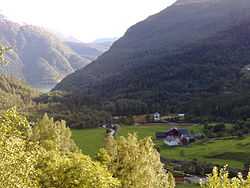
Gjetingsdalen
From Wikipedia, the free encyclopedia
| Gjetingsdalen, Hordaland | |
|---|---|
| Village | |
 | |
 | |
| Coordinates: 60°8′5″N 6°13′55″E / 60.13472°N 6.23194°ECoordinates: 60°8′5″N 6°13′55″E / 60.13472°N 6.23194°E | |
| Country | Norway |
| Region | Western Norway |
| County | Hordaland |
| Founded | 1884 |
| Area | |
| • Total | 0.5 sq mi (1.4 km2) |
| • Land | 0.5 sq mi (1.4 km2) |
| • Water | 0.0 sq mi (0.0 km2) |
| Elevation | 823 ft (251 m) |
| Population (2009) | |
| • Total | 16 |
| • Density | 30/sq mi (11.4/km2) |
| Time zone | Central (CET) (UTC1) |
| • Summer (DST) | CDT (UTC+1) |
| ZIP code | 5476 |
| Area code(s) | 5476 |
Gjetingsdalen is a valley in Mauranger in Kvinnherad communes, Norway.
This article is issued from Wikipedia. The text is available under the Creative Commons Attribution/Share Alike; additional terms may apply for the media files.