Giza Plateau
From Wikipedia, the free encyclopedia

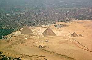
From north to south: parts of the city of Giza, the Giza Necropolis, and part of the Giza plateau
The Giza Plateau (Arabic: جيزة بلاتي) is a plateau that is located in Giza, Egypt. The famous Giza Necropolis is located in this geographical area, which is characterized by a sandy, desert climate and terrain with little vegetation.
The plateau and its monuments have been recorded in the Giza Plateau Mapping Project run by Ancient Egypt Research Associates, directed by Dr. Mark Lehner.[1] AERA's 2009 field season was recorded in a blog.[2]
Since the Egyptian Revolution of 2011 looting has been taking place at the site.[3]
References
- ↑ "The Giza Plateau Mapping Project", Leher, Mark; Hunt, Brian V. link
- ↑ "An archaeology blog from the Giza Pyramids in Egypt", 2009 Hunt, Brian V. link
- ↑ Hartley, Aiden (09 November 2013). "The new tomb raiders". The Spectator (UK). Retrieved 10 November 2013.
| |||||||||||||||||||||||||
Coordinates: 29°58′34″N 31°07′58″E / 29.97611°N 31.13278°E
This article is issued from Wikipedia. The text is available under the Creative Commons Attribution/Share Alike; additional terms may apply for the media files.
