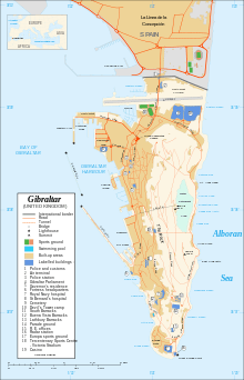
Gibraltar–Spain border
Coordinates: 36°09′18″N 5°20′54″W / 36.154933°N 5.348363°W


The Gibraltar–Spain border is the international boundary[1] between the British Overseas Territory of Gibraltar and Spain. It is also referred to as Spanish: La frontera de Gibraltar (The frontier of Gibraltar) or simply as The Frontier.[2]
The border runs east-west for a total of 1.2 kilometres (0.75 mi) separating Gibraltar from the neighbouring Spanish municipality of La Línea de la Concepción.[3] Since the United Kingdom is outside the European Union's Schengen Area, Gibraltar is too and therefore, identity checks are required to cross the border.[4]
History
The frontier has not always been marked by a barrier. In 1909 Britain was aware of the need to reduce the number of sentries and built a fence 7 ft (c. 2m) high,[5] however there was suspicion about the motives for the fence.[6]
Spain closed the border to vehicles in 1969 and again completely later on in the year following heightened tensions with Britain as a result of the disputed status of Gibraltar. The border was not fully reopened until February 1985.
References
- ↑ The Kingdom of Spain does not recognize the existence of an international boundary. isthmus_between_Gibraltar_and_Spain
- ↑ Olivero, Leo (6 July 2012). "Fear of crossing the Frontier!". Panorama. Retrieved 29 July 2012.
- ↑ "Length of Land Boundaries Border Countries by Country". Chartsbin. Retrieved 29 July 2012.
- ↑ Garcia, Joe. "Spain would not object to Gibraltar joining Schengen". Panorama. Retrieved 29 July 2012.
- ↑ Simon J. Lincoln (1994). "The Legal Status of Gibraltar: Whose Rock is it Anyway?". Fordham International Law Journal, Volume 18, Issue 1 page 308. Retrieved 2013-09-26.
- ↑ Jackson, Sir William G. F. (1990). The rock of the Gibraltarians : a history of Gibraltar (2nd ed. ed.). Grendon: Gibraltar Books. p. 262. ISBN 0948466146.
See also
| Wikimedia Commons has media related to Border crossings of Gibraltar. |
| ||||||||||||||