Gharsana tehsil
Gharsana Tehsil (In Hindi and Rajasthani घङसाना, तहसील in Punjabi ਘੜਸਾਨਾ ਤਹਿਸੀਲ) is the one of 9 tehsils of Shrigangagnagar district of Rajasthan, India. Gharsana tehsil is the southernmost tehsil of District Shri Ganganagar. It is bordered by Anupgarh tehsil in the north, by Chhatargarh, Pugal and Khajuwala, tehsils of Bikaner district in the southeast. The western border touches Fort Abbas Tehsil of Bahawalnagar district of Pakistani Punjab.
History


Old villages and towns
Rojri, Dhandhu, Sataiyan, Khobar, Khanuwali, Kodiband, and Shekhra, 6 DD, Dabbar, 465 Head, Lunia, Dhabban, Satrana, Jalwali are old towns of this tehsil.

Geography
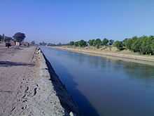
This tehsil is a part of Thar desert. Sandy dunes and horny shrubs, trees are a basic characteristics of the area. Irrigation by Anoopgarh branch canal has encouraged agriculture activities in the area. Currently, sandy dunes and green fields can be seen.
Economy


Rajasthan Cooperative Dairy Federation (RCDF) has established a Seed Multiplication farm at Rojhri. It develops seeds for fodder.
Religions of Gharsana tehsil

Languages
Hindi is the official language but the Bagri language, a dialect of Rajasthani, is spoken by the majority of people. Punjabi is the second most important language. Saraiki, which some consider to be a dialect of the Punjabi language, is also spoken by a few people. Odh and Bawri people speak their own unique language.
Culture
Bagri and Punjabi cultures dominate the tehsil.
Clothing
The embroidered odhni (usually of a red colour) is a symbol of Bagri women. Long shirt and ghaghro (long frock type clothes) and Borlo (a head ornament) are worn as the traditional dress of Bagri women. Punjabi women wear the kurta and salwar with a chunni, a cloth worn over the head. This dress has also become popular with women of other communities. Some women of Hindu and Muslim Seraiki people still wear the ghagra (long frock). The purdah (veil) custom has been in vogue among Bagri women.
Men have worn mainly pant-shirt, kurta-payjama or dhoti (which the Punjabi call chadara) and kurta.
Tourist attractions
In the Guruduara, on the Anupgarh-Gharsana Road, Gharsana town, are paintings related to Sikh history and saints.
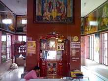
In the south-western part of Gharsana tehsil, on the Gharsana-Bikaner Road, at Rojari village, is the temple complex of Rojhri dham. This place is associated with the Hindu god Hanuman.
The shrine of Peer Gullu is located near Sakhi village. It is a small building surrounded by large sandy dunes. At the time of the fair, this sandy area fills up with a large gathering of devotees of the Peer and visitors. It is one of the largest fairs of the tehsil, with wrestling (Indian style) in the evenings.
Fauna (Animals)

The waters of canals has changed both flora and faunas of this area.Apart from domestic and common animals Gharsana area has also some wild animals.Rojh or Neelgai (Boselaphus tragocamelus) are common mammals found in farms and sandy dunes.Farmers have to care about their crops from these animals.Sometimes Neelgai comes on roads and becomes reason of accidents. The snakes.Goh,Sanha(Sanda),Wild rats etc. are other wild animals of this area.
Chartered Accountant
Gharsana has produced many CA's that's why today gharsana is called "Home of CA". At present more than 15 students cleared CA which includes, Prashant Maheshwari, Pankaj Bothra, Sandeep Kukkar, Mohan Lal, Shyam Sarswat, Lalit Goyal, Anil Jain and many more. Even currently more than 100 students preparing for CA including Ajay Jindal, Ajay lakhotia, Gaurav Pareek which will become member of this fraternity soon
Transport

Major villages
The major villages include: New Mandi Gharsana, Rawla Mandi, Rojri, 365 Head, Khanuwali, Old Mandi Gharsana, Sakhi, Jalwali, 32 Wali Puli, 5 Mld, 12 Mld, 10 GlD 17 Md, 22 RJD. {22 MD}
Gallery
|
External links
- More information about the villages and irrigation of Gharsana tehsil district.
- Information about schools, teachers and education.
- Bikaner University
| ||||||||


