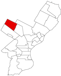
Germantown Township, Pennsylvania

Germantown Township, also known as German Township, is a defunct township that was located in Philadelphia County, Pennsylvania. The municipality ceased to exist and was incorporated into the City of Philadelphia following the passage of the Act of Consolidation, 1854.
History
Germantown Township, was laid out by virtue of three warrants: October 12, 1683, for 6,000 acres (24 km²), to Francis Daniel Pastorius, for the German and Dutch purchasers; February 13, 1683, to Francis Daniel Pastorius for 200 acres (0.81 km2); April 25, 1684, to Jurian Hartsfelder, for 150 acres (0.61 km2).
In 1688, Francis Pastorius drew up the first documented protest against negro slavery in American history.
The first purchasers of land in the township were from Frankfurt, Germany, they were Jacobus van der Walle, Johann Jacob Schutz, Johann Wilhelm Ueberfeld, Daniel Behagel, George Strauss, Jan Leureiss, Abram Hasevoet. Among them were divided 2,675 acres (11 km²) of land. The same quantity was divided among the first purchasers from Crevelt, Germany, namely, Jacob Felner, Jan Strepers, Dirk Sipman, Ganert Reniks, Lenard Artes, Jacob Isaacs.
The township was divided into settlements, called Germantown, Cresheim, Sommerhausen and Crevelt. These Germans were from the palatinates of Cresheim and Crevelt, many of them having become Friends through the preaching of William Penn in Germany.
The greatest length of the Germantown Township was 5½ miles; the greatest breadth, 2 miles (3.2 km); area, 7,040 acres (28 km²). The township was bounded on the northwest and northeast by Springfield Township, Montgomery County on the northeast partly by Bristol Township; on the southeast by Penn Township and Roxborough Township. Within Germantown Township were the settlements known as Germantown, Cresheim (afterwards Mount Airy), Sommerhausen (later called Chestnut Hill) and Crevelt, a rural section north of Chestnut Hill.
Resources
- Chronology of the Political Subdivisions of the County of Philadelphia, 1683–1854
- Information courtesy of ushistory.org
- Incorporated District, Boroughs, and Townships in the County of Philadelphia, 1854 By Rudolph J. Walther - excerpted from the book at the ushistory.org website
Coordinates: 40°02′20″N 75°11′02″W / 40.039°N 75.184°W