Geiselbach (river)
From Wikipedia, the free encyclopedia
 | |
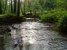
| The Geiselbach in Teufelsgrund | |
| Location | Bavaria, Hesse, |
|---|---|
| Reference no. | DE: 247728 |
| Length | 5.2 km [1] |
| Source | near Geiselbach 50°07′27″N 9°12′29″E / 50.124292°N 9.208045°ECoordinates: 50°07′27″N 9°12′29″E / 50.124292°N 9.208045°E |
| Mouth | near Niedersteinbach in the Kahl 50°05′32″N 9°08′31″E / 50.092186°N 9.141976°E |
| Basin | Rhine |
| Progression | Kahl → Main → Rhine → North Sea |
The Geiselbach is a right tributary of the Kahl in the northern Spessart in Bavaria and Hesse, Germany. It is 5,2 km (3,2 mi) long and begins at the confluence of multiple headstreams in Geiselbach. The largest tributary is the Omersbach. It discharges near the Teufelsmühle ("Devil's Mill"). The Geiselbach flows through the Teufelsgrund ("Devil's Valley") to Hüttelngesäß and forms the border between Hesse and Bavaria. Near the old ruins it empties in the Kahl.
The Geiselbach is with Westerbach, Sommerkahl and Reichenbach one of the largest tributaries of the Kahl.
Tributaries
- Omersbach (left)
References
- ↑ GeoinformationsSystem des Bayerischen Landesamtes für Umwelt
-
a headstream of the Geiselbach
-
near Hüttelngesäß
-
the mouth in the Kahl
| Wikimedia Commons has media related to Geiselbach (River). |
This article is issued from Wikipedia. The text is available under the Creative Commons Attribution/Share Alike; additional terms may apply for the media files.


