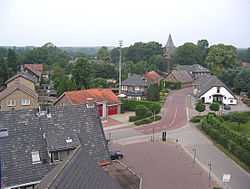
Garderen
| Garderen | |
|---|---|
| Municipality | |
 | |
 | |
| Coordinates: 52°13′N 5°42′E / 52.21°N 5.7°E | |
| Country | Netherlands |
| Province | Gelderland |
| Population (1 January 2008) | |
| • Total | 1,994 |
| Source: CBS, Statline.[1] | |
| Time zone | CET (UTC+1) |
| • Summer (DST) | CEST (UTC+2) |

Garderen is a village in the Dutch province of Gelderland. It is located in the municipality of Barneveld, in the forests of the Veluwe. The village has 1,994 inhabitants (as of 1 January, 2008).
Garderen was a separate municipality until 1818, when it was merged with Barneveld.[2]
Location
The village is located in an agricultural enclave on the west side of the Veluwe. It has been a tourist destination for a long time, owing to its bed & breakfasts with high-quality food, but it has always remained a conservative and religious village.
Services
The village has a primary school, a practice, a Restored Reformed Church, a reformed town within the PKN, a continuing Reformed Church, a cemetery, band Tog mill De Hoop, various hotels, restaurants, cafes and snack bars, campgrounds, shops basic and several dozen other companies. Garderen center has a function for the villages Speuld, Stroe and Kootwijk. Even residents of the neighborhoods Wood Village, More Field, New Milligen and Cold Horn often have a focus on the village Garderen.
History
Garderen is older than the village of Barneveld and was originally the capital of the later city Barneveld. The church of the Dutch Reformed Church was originally built in the eleventh century. The current tower dates from the fourteenth century. From 1812 to 1818 Garderen was an independent municipality, now a separate cadastral designation. After this it became part of the municipality of Barneveld.
Serbian monuments
At the cemetery, there is a Serbian war memorial, in memory of the 29 Serb soldiers who were killed by the Spanish flu shortly after the First World War. They were part of a large group of Serbian soldiers who were temporarily housed in the 'Lombok' barracks at the nearby Camp Milligen. In 2007, by order of the Committee, the manager of the cemetery Veluwehof Stone from Voorthuizen started to renew the monument, and in stages, to expand it.
References
- ↑ Inwonersaantal gemeente Barneveld
- ↑ Ad van der Meer and Onno Boonstra, Repertorium van Nederlandse gemeenten, KNAW, 2006.
External links
- J. Kuyper, Gemeente Atlas van Nederland, 1865-1870, "Garderen". Map of the former municipality, around 1868.
Coordinates: 52°14′N 5°43′E / 52.233°N 5.717°E