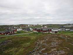
Gamvik (village)
| Gamvik | |
|---|---|
| Village | |
 | |
 Gamvik | |
| Coordinates: 71°03′49″N 28°14′48″E / 71.06361°N 28.24667°ECoordinates: 71°03′49″N 28°14′48″E / 71.06361°N 28.24667°E | |
| Country | Norway |
| Region | Northern Norway |
| County | Finnmark |
| District | Øst-Finnmark |
| Municipality | Gamvik |
| Elevation[1] | 5 m (16 ft) |
| Time zone | CET (UTC+01:00) |
| • Summer (DST) | CEST (UTC+02:00) |
| Post Code | 9775 Gamvik |
Gamvik is a fishing village in Gamvik Municipality in Finnmark county, Norway. The village is located on the northern shore of the Nordkinn Peninsula, along the Barents Sea. The village is the second largest settlement in Gamvik municipality, after Mehamn which is located about 16 kilometres (9.9 mi) to the west. Gamvik is home to the Gamvik Museum and Gamvik Church. The village is an old church site with churches located here since at least the 1850s.[2]
The village was historically only accessible by boat, but due to the poor harbor conditions, the daily Hurtigruten steamers had to drop anchor a little way out from the shore and then smaller boats had to ferry people into the village. In the 1970s, Gamvik Airport was built and in the 1980s, Norwegian County Road 888 was built from Mehamn to Gamvik.
Slettnes Lighthouse is located about 3 kilometres (1.9 mi) north of the village, and it is the northernmost mainland lighthouse in Norway. Slettnes nature reserve is also located north of the village and it is an important breeding ground for a large number of bird species, and it is home to the second largest colony of Parasitic Jaegers. The remains of the old Gamvik Airport as well as some ruins of World War II fortifications are found to the north of the village.
Media gallery
-

View of the village
-

View of the church and historic fortifications
-
View of the village
-
View of the harbor
References
- ↑ "Gamvik" (in Norwegian). yr.no. Retrieved 2013-02-23.
- ↑ Store norske leksikon. "Gamvik kirke" (in Norwegian). Retrieved 2013-02-23.

