Gainfield
From Wikipedia, the free encyclopedia
Coordinates: 51°39′29″N 1°29′49″W / 51.658°N 1.497°W
| Gainfield | |
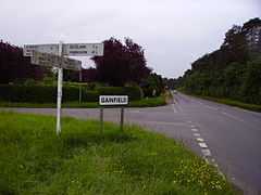
 Gainfield crossroads, with the Warren on the right of the picture |
|
 Gainfield | |
| OS grid reference | SU3495 |
|---|---|
| Civil parish | Buckland |
| District | Vale of White Horse |
| Shire county | Oxfordshire |
| Region | South East |
| Country | England |
| Sovereign state | United Kingdom |
| Post town | Faringdon |
| Postcode district | SN7 |
| Dialling code | 01367 |
| Police | Thames Valley |
| Fire | Oxfordshire |
| Ambulance | South Central |
| EU Parliament | South East England |
| UK Parliament | Wantage |
| |
Gainfield is a small ribbon development in Buckland civil parish about 4 miles (6.4 km) east of Faringdon in the Vale of the White Horse District of England. It was part of Berkshire until the 1974 boundary changes transferred it to Oxfordshire.
Buckland is on the B4508 road by the crossroads with the road between Buckland and Charney Bassett, about 1.5 miles (2.4 km) north of Stanford in the Vale. It is opposite a wood called Buckland Warren.
There is a legend, linked with that of nearby Cherbury Camp, that tells of the land being given as a reward to a young shepherd boy who saved the inhabitants of the camp by his vigilance.[1]
References
- ↑ Ford, David Nash (2001). "Gainfield". Royal Berkshire History. Nash Ford Publishing. Retrieved 16 October 2011.
This article is issued from Wikipedia. The text is available under the Creative Commons Attribution/Share Alike; additional terms may apply for the media files.
