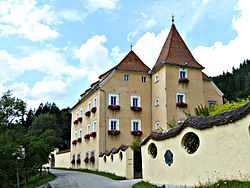
Gai, Styria
From Wikipedia, the free encyclopedia
| Gai | ||
|---|---|---|
 | ||
| ||
 Gai | ||
| Coordinates: 47°24′47.38″N 14°58′11.49″E / 47.4131611°N 14.9698583°ECoordinates: 47°24′47.38″N 14°58′11.49″E / 47.4131611°N 14.9698583°E | ||
| Country | Austria | |
| State | Styria | |
| District | Leoben | |
| Government | ||
| • Mayor | Anton Kogler (ÖVP) | |
| Area | ||
| • Total | 62.22 km2 (24.02 sq mi) | |
| Elevation | 660 m (2,170 ft) | |
| Population (1 January 2013)[1] | ||
| • Total | {{Metadata population AT-6}} - Unknown metadata keyword: 61,102 | |
| Time zone | CET (UTC+1) | |
| • Summer (DST) | CEST (UTC+2) | |
| Postal code | 8793 | |
| Area code | 03847 | |
| Vehicle registration | LN | |
| Website | www.gai.steiermark.at | |
Gai is a municipality in the district of Leoben in the Austrian state of Styria.
Geography
Gai lies about 10 km northwest of Leoben on the Styrian Eisenstraße, 3 km southwest of Trofaiach.
References
| |||||
This article is issued from Wikipedia. The text is available under the Creative Commons Attribution/Share Alike; additional terms may apply for the media files.
