Gage Roads
Coordinates: 32°2′43″S 115°40′53″E / 32.04528°S 115.68139°E

Gage Roads is the sea channel in the Indian Ocean offshore from Fremantle, Western Australia.
The roads hosted the 1987 America's Cup, and serve as a shipping lane and anchorage for sea traffic heading towards the seaport of Fremantle, which rounds the north of Rottnest before entering.
Rottnest Island lies to the west and Cockburn Sound to the south.
Coastal geology
The area is the most northern of one of four coastal basins formed from the flooding of a depression between Pleistocene aeolianite ridges running north-south, and the subsequent deposition of east-west Holocene banks. The seabed of Gage Roads is covered by seagrass.
Naming
Shipping reports
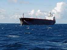
Gage Roads is identified in shipping reports in local newspapers of ships at anchor, prior to entering the port of Fremantle.[2][3]
Anchorage
At certain times, over 10 ships can be seen anchored in Gage Roads waiting to enter the port of Fremantle. In addition to these waiting ships, over-sized ships that are unable to enter the inner harbour due to size or draft are required to be at anchor in Gage Roads.[4]
Cruising
In the early 1900s, the local boat SS Zephyr regularly took cruises in Gage Roads.[5] In the 2000s, the STS Leeuwin II and others have used Gage Roads for short sailing cruises.
War time
During the World War II era, the Leighton Guns (also known as Leightin Battery) on Buckland Hill were part of the main anti-aircraft defence of the Gage Roads area.
The guns were still operable into the Gage Roads area in the 1950s.[6][7]
Swimming
The Rottnest Channel Swim course (an annual swimming event) starts at Cottesloe beach and crosses Gage Roads before finishing at Rottnest Island.
Notes
- ↑ Gage Roads - named by Captain Stirling in 1827 after Rear Admiral Gage - The Sunday Times (Perth, W.A.), 4 Jan. 1987, p.32d
- ↑ "Gage Roads.". The West Australian (Perth, WA : 1879 - 1954) (Perth, WA: National Library of Australia). 8 November 1937. p. 17. Retrieved 8 April 2013.
- ↑ "GAGE ROADS.". The West Australian (Perth, WA : 1879 - 1954) (Perth, WA: National Library of Australia). 1 November 1938. p. 13. Retrieved 8 April 2013.
- ↑ http://www.fremantleports.com.au/About/History/Pages/Port%27s-wartime-role.aspx Fremantle Ports website - Fremantle Harbour war time role
- ↑ "Gage Roads.". The Daily News (Perth, WA : 1882 - 1950) (Perth, WA: National Library of Australia). 15 May 1914. p. 9 Edition: Third Edition. Retrieved 8 April 2013.
- ↑ "Big Guns Do Their Bit.". The West Australian (Perth, WA : 1879 - 1954) (Perth, WA: National Library of Australia). 3 April 1954. p. 12. Retrieved 8 April 2013.
- ↑ "Coast Guns To Fire.". The West Australian (Perth, WA : 1879 - 1954) (Perth, WA: National Library of Australia). 17 May 1950. p. 17. Retrieved 8 April 2013.