Frechen
| Frechen | ||
|---|---|---|
 | ||
| ||
 Frechen | ||
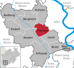
Location of Frechen within Rhein-Erft-Kreis district 
 | ||
| Coordinates: 50°55′N 6°49′E / 50.917°N 6.817°ECoordinates: 50°55′N 6°49′E / 50.917°N 6.817°E | ||
| Country | Germany | |
| State | North Rhine-Westphalia | |
| Admin. region | Köln | |
| District | Rhein-Erft-Kreis | |
| Subdivisions | 9 | |
| Government | ||
| • Mayor | Hans-Willi Meier (CDU) | |
| Area | ||
| • Total | 45.11 km2 (17.42 sq mi) | |
| Elevation | 58 - 158 m (−500 ft) | |
| Population (2012-12-31)[1] | ||
| • Total | 50,607 | |
| • Density | 1,100/km2 (2,900/sq mi) | |
| Time zone | CET/CEST (UTC+1/+2) | |
| Postal codes | 50226 | |
| Dialling codes | 02234 | |
| Vehicle registration | BM | |
| Website | www.stadt-frechen.de | |
Frechen is a town in the Rhein-Erft-Kreis, in North Rhine-Westphalia, Germany. Frechen was first mentioned in 877. It is situated at the western Cologne city border.
It is the site of the 1257 Battle of Frechen between Conrad von Hochstaden, Archbishop of Cologne and the people of the town. In the 16th century it acquired a name for its terra cotta artifacts, especially the "Bartmannskrug" (beardman jug). Later in the 18th century lignite was first industrially mined. Digging for lignite dominated the city's economy until the end of the 20th century. In 1891 the first briquette factory was opened. On 2 September 1951 Frechen received its city-rights including the towns of Bachem and Buschbell. On 1 January 1975 the nearby villages of Grefrath, Habbelrath, Königsdorf and Neufreimersdorf were also incorporated.
As of January 31, 2008 there were 51.387 inhabitants registered.

References
- ↑ "Amtliche Bevölkerungszahlen". Landesbetrieb Information und Technik NRW (in German). 31 July 2013.
External links
| Wikimedia Commons has media related to Frechen. |
| |||||||
