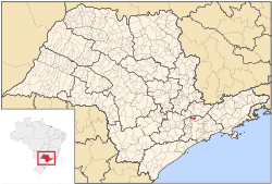
Franco da Rocha
From Wikipedia, the free encyclopedia
| Franco da Rocha | |||
|---|---|---|---|
| Municipality | |||
 | |||
| |||
 | |||
 Franco da Rocha | |||
| Coordinates: 23°19′43″S 46°43′28″W / 23.32861°S 46.72444°W | |||
| Country |
| ||
| Region | Southeast | ||
| State |
| ||
| Government | |||
| • Mayor | Kiko Celeguim (PT) | ||
| Area | |||
| • Total | 133.931 km2 (51.711 sq mi) | ||
| Population (2007)[1] | |||
| • Total | 121,451 | ||
| • Density | 906.82/km2 (2,348.7/sq mi) | ||
| Time zone | UTC-3 (UTC-3) | ||
| • Summer (DST) | UTC-2 (UTC-2) | ||
| HDI (2000) | 0,778 – medium | ||
| Website | Franco da Rocha | ||
Coordinates: 23°19′43″S 46°43′28″W / 23.32861°S 46.72444°W
Franco da Rocha is a municipality in the state of São Paulo in Brazil. The population in 2006 was 124,816, its density is 931.9 inh./km² and the area is 134 square kilometres (52 sq mi).
The suburban city is served by CPTM Line 7 (Ruby).
References
- ↑ "Estimativas - Contagem da População 2007". IBGE. Retrieved 2008-07-11.
 |
Várzea Paulista, Campo Limpo Paulista and Francisco Morato |  | ||
| Cajamar | |
Mairiporã | ||
| ||||
| | ||||
| Caieiras |
| ||||||||||||||||||||||||||||||||||||||||||||||||||||||||||||
| Wikimedia Commons has media related to Franco da Rocha. |
This article is issued from Wikipedia. The text is available under the Creative Commons Attribution/Share Alike; additional terms may apply for the media files.

