Fort Manoel
| Fort Manoel | |
|---|---|
| Manoel Island, Gżira, Malta | |
_02_ies.jpg) | |
| View of Fort Manoel from Marsamxett | |
| Type | Coastal fortification |
| Site information | |
| Condition | Intact, recently restored |
| Site history | |
| Built | 1723 |
| In use | 1755-1906 1940s |
| Built by | Order of Saint John |
| Materials | Limestone |

Fort Manoel is a fortification on the island of Malta. It stands on Manoel Island in Marsamxett Harbour to the north west of Valletta and commands the entrance to Marsamxett Harbour and the anchorage of Sliema Creek. Fort Manoel is a star fort, with much of its ditches and walls formed from the native rock of Manoel Island.
History
The fort was built by the Knights of Malta between 1723 and 1755, under the patronage of Portuguese Grand Master Manoel de Vilhena.
The original design work for a fort on the island, then known as Isolotto, was the work of the French engineer René Jacob de Tigné. The final design also incorporated the work of Charles François de Mondion, at that time the Knights of Malta's resident military engineer in charge of works of fortification and defence. Mondion also supervised the construction, and was hypothetically buried in the fort's chapel, St. Anthony’s Chapel.
The fort was an active military establishment initially under the Knights and later under British Military control from its construction through until 1906 when the British military finally decommissioned the forts guns.
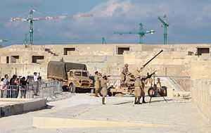
During the Second World War, a battery of 3.7-inch heavy anti-aircraft guns was deployed in and around the fort. The guns were mounted in concrete gun emplacements and deployed in a semicircle around the fort. The fort suffered considerable damage to its ramparts, barracks and chapel as a result of aerial bombing during the war.
In 2010, the fort underwent major restoration work to repair the ravages of time and damage sustained during the Second World War. It served as a location for the shooting of the climactic scene of the episode Baelor of the TV series Game of Thrones. This was one of the strongest fortifications.
References
| Wikimedia Commons has media related to Fort Manoel. |