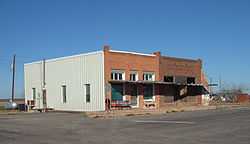
Fluvanna, Texas
| Fluvanna, Texas | |
|---|---|
| Community | |
 | |
 Fluvanna | |
| Coordinates: 32°53′08″N 101°08′55″W / 32.88556°N 101.14861°WCoordinates: 32°53′08″N 101°08′55″W / 32.88556°N 101.14861°W | |
| Country |
|
| State |
|
| County | Scurry |
| Region | West Texas |
| Established | 1908 |
| Elevation[1] | 2,674 ft (815 m) |
| Population (2000)[2] | |
| • Total | 180 |
| Time zone | CST (UTC-6) |
| Website | Handbook of Texas |
Fluvanna is located in Scurry County, just south of the Llano Estacado high atop the caprock in West Texas, where Farm-to-Market Road 1269 and Ranch Road 612 intersect.
Fluvanna is named for a surveyor's home county — Fluvanna County, Virginia.[3] Fluvanna was established by realty promoters who knew that the Roscoe, Snyder and Pacific Railway would terminate at this site.[4] Fluvanna's importance lessened when the Roscoe, Snyder and Pacific closed the Fluvanna station in 1941 and major highways bypassed the area.[3] The population dropped from a high of 500 in 1915 to 180 in the 2000 Census.[2] In recent years, all businesses except the post office have closed in downtown Fluvanna.
Gallery
-
Fluvanna Post Office
-

Brazos Wind Farm, Fluvanna, Texas
-

Farm-to-market road 1269
See also
- Caprock Escarpment
- Double Mountain Fork Brazos River
- Duffy's Peak
- Farm to Market Road 669
- Mushaway Peak
- Salt Fork Brazos River
References
- ↑ "Fluvanna". Geographic Names Information System, U.S. Geological Survey.
- ↑ 2.0 2.1 Census 2000 Data for the State of Texas, http://www.census.gov/census2000/states/tx.html
- ↑ 3.0 3.1 Handbook of Texas Online, "Fluvanna, TX", http://www.tshaonline.org/handbook/online/articles/hlf18 (accessed January 27, 2009).
- ↑ Scurry County Historical Survey Committee. Historical Markers in Scurry County. Published by Scurry County Historical Survey Committee. 1969. First Edition.
External links
- U.S. Geological Survey Geographic Names Information System: Fluvanna
- Fluvanna, TX from the Handbook of Texas Online
- Photos of West Texas and the Llano Estacado
| |||||||||||||||||

