Flemington Road, Melbourne
From Wikipedia, the free encyclopedia
| Flemington Road Victoria | |
|---|---|
| General information | |
| Type | Road |
| Length | 2 km (1 mi) |
| Route number(s) |
|
| Former route number |
|
| Major junctions | |
| Southeast end |
|
| |
| Northwest end |
|
| Location(s) | |
| Major suburbs | Parkville |
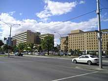
The Royal Children's Hospital, located on Flemington Road.
Flemington Road is a major thoroughfare in the inner suburbs of North Melbourne and Parkville in Melbourne, Victoria, Australia. It runs from the north end of Elizabeth Street to the south end of Mount Alexander Road, Flemington, and provides a main connection between the Melbourne CBD and the northern arm of the CityLink tollway.
The road is the location of the Royal Children's Hospital, the Royal Melbourne Hospital, and the southern border of Royal Park. The road consists of four car lanes and one tram track lane in both directions, and is serviced by Melbourne tram numbers 55, 57 and 59.
See also
![]() Australian Roads portal
Australian Roads portal
Coordinates: 37°47′40″S 144°56′54″E / 37.79444°S 144.94833°E
This article is issued from Wikipedia. The text is available under the Creative Commons Attribution/Share Alike; additional terms may apply for the media files.