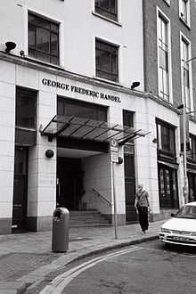
Fishamble Street

Fishamble Street (Irish: Sráid Sheamlas an Éisc) is a street in Dublin, Ireland within the old city walls.
The street joins Wood Quay at the Fish Slip near Fyan's Castle. It is mentioned in the 14th century as Vicus Piscariorum and as Fish Street. In 1577, Stanihurst named it as St John's Street. In 1610, some editions of Speed's map call it Fish Shambles.
The street was known as the official fish market for Dublin until the end of the 17th century, when the city markets were moved to the north bank of the Liffey. ("Shambles" were meat markets and open-air slaughterhouse districts, and the word occurs in several British and Irish street names, such as The Shambles in York.)
From 1680, around about the time the fish market was moved, the General Post Office was located here and remained for 30 years. The Church of St. John the Evangelist was located here until it was demolished in the 1880s.
Fishamble Street was the birthplace of James Clarence Mangan, 19th-century poet.
Taverns
In the 18th century, a tavern on the street, the Bull's Head, was one of the most popular and well-known establishments in Dublin, and was in demand for anniversary and celebratory dinners by the various city guilds and bodies. It also provided accommodation for assemblies of the Grand Lodge of Irish Freemasons. The Bull's Head Musical Society was also well known and undertook the building of a Music Hall which was formally opened in 1741.[1]
The street is famous as the site of the first performance of Handel's Messiah, which took place in the aforementioned Music Hall on 13 April 1742 before an audience of approximately 700 people. A pub further up on Thomas Street was known as G. F. Handel's before changing its name to Arthur's.
Podcasts
- You can hear the 2010 concert of Handel's Messiah recorded at Fishamble Street in Dublin at http://www.podcasts.ie/2010/04/handels-messiah-concert-fishamble-street-april-13th-2010/
References
- ↑ de Courcy, J. W. (1996). The Liffey in Dublin. Gill & Macmillan. p. 468. ISBN 0-7171-2423-1.
Coordinates: 53°20′38″N 6°16′12″W / 53.34389°N 6.27000°W