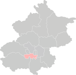
Fengtai District
| Fengtai 丰台 | |
|---|---|
| District | |
| 丰台区 | |
 | |
 | |
| Country | People's Republic of China |
| Municipality | Beijing |
| Township-level divisions |
14 subdistricts 2 town 5 townships |
| Area | |
| • Total | 306 km2 (118 sq mi) |
| Population | |
| • Total | 1,360,000 |
| • Density | 4,400/km2 (12,000/sq mi) |
| Time zone | China Standard (UTC+8) |
| Postal code | 100071 |
| Area code(s) | 0010 |
| Website | www.bjft.gov.cn |
Fengtai District (simplified Chinese: 丰台区; traditional Chinese: 豐台區; pinyin: Fēngtái Qū) is a district of the municipality of Beijing. It lies to the southwest of the city center, extending into the city's southwestern suburbs.
History
In Qing Dynasty times, Fengtai was where the Imperial Manchu Army had its camps, trained, and held parades on festive occasions.[citation needed]
It is 304.2 square kilometres (117.5 sq mi) in area, making it the third-largest precinct in the greater urban part of Beijing, and is home to 790,000 inhabitants.
It is divided into 14 subdistricts of the city proper of Beijing, 2 towns, and 5 townships (2 of which are suburbs of the city proper of Beijing). This precinct is newly urbanized in comparison to those precincts in the old city, and until mid-1980s, it was still a mostly rural area where pig pens and goat pens were common, and major parts of the precinct had no electricity. It was only during the recent rapid economic development that the precinct was urbanized. Its postal code is 100071.[citation needed]
Changxindian (population 78,092) and Yungang (population 32,894) Subdistricts of Beijing make up an urban area distinct from Beijing.[citation needed]
The district is mainly an industrial area (there are Beijing county level development zones including Fengtai Baipengyao Industrial Warehousing Area, Fengtai Changxindian Industrial Area, Fengtai materials Transport Area), but there are several cultural and historical sites such as the China Space Museum, Fengtai Park, and the Marco Polo Bridge (Lugou Bridge).
Administrative divisions
The district administers 14 subdistricts, 2 towns, and 5 townships.[1]
Subdistricts:
- Fengtai Subdistrict (丰台街道), You'anmen Subdistrict (右安门街道), Taipingqiao Subdistrict (太平桥街道), Xiluoyuan Subdistrict (西罗园街道), Dahongmen Subdistrict (大红门街道), Nanyuan Subdistrict (南苑街道), Donggaodi Subdistrict (东高地街道), Dongtiejiangying Subdistrict (东铁匠营街道), Lugouqiao Subdistrict (卢沟桥街道), Xincun Subdistrict (新村街道), Changxindian Subdistrict (长辛店街道), Yungang Subdistrict (云岗街道), Majiabao Subdistrict (马家堡街道), Heyi Subdistrict (和义街道)
Towns:
- Changxindian Town (长辛店镇), Wangzuo (王佐镇)
Areas (Townships):[2]
- Fangzhuang (方庄地区), Yuanpingcheng (宛平城地区), Lugouqiao Township (卢沟桥地区), Huaxiang (花乡地区), Nanyuan Township (南苑地区)
Communities
Transportation
The southwestern stretches of the 3rd Ring Road, 4th Ring Road and 5th Ring Road all run through the area, as well as the Jingshi Expressway (Jingzhu Expressway).
Beijing Nanyuan Airport is located in the district.
Tourism
- Beijing World Park
- White Cloud Temple
- Marco Polo Bridge
- Wanping Fortress, at the eastern end of the bridge
- Museum of the War of Chinese People's Resistance Against Japanese Aggression, inside the fortress
Economy
China United Airlines has its headquarters in Fengtai District.[3] Okay Airways previously had its headquarters in Fengtai District.[4][5]
References
Notes
- ↑ "2011年统计用区划代码和城乡划分代码:丰台区" (in Simplified Chinese). National Bureau of Statistics of the People's Republic of China. Retrieved 2013-08-07.
- ↑ These are officially classified as townships, but as they coincide with the area of the same name, they are commonly named "areas" (地区)
- ↑ "联系我们." China United Airlines. Retrieved on October 12, 2012. "北京市丰台区警备东路6号西区一号院"
- ↑ "北京总公司." Okay Airways. Retrieved on October 4, 2009. "北京总公司" and "北京市丰台区方庄芳星园三区18号"
- ↑ "China to approve private airline - report.(Okay Airways Co)(Brief Article)." Airline Industry Information. February 22, 2005. Retrieved on October 4, 2009.
General references
- Harper, Damian, Beijing: City Guide, 7th Edition, Oakland, California: Lonely Planet Publications, 2007. Cf. pp. 96–98, 138, 266-267.
- Harper, Damian, Beijing: City Guide, 6th Edition, Oakland, California : Lonely Planet Publications, 2005. ISBN 1-74059-782-6. Cf. section beginning on p. 88, "Fengtai & Xuanwu".
External links
- Fengtai District, Beijing Municipality (Chinese)
| |||||||||||||||||||||||||||||||
Coordinates: 39°49′42″N 116°16′56″E / 39.828273°N 116.282161°E