Felsőcsatár
From Wikipedia, the free encyclopedia
| Felsőcsatár | |
|---|---|
 | |
 Felsőcsatár | |
| Coordinates: 47°12′54″N 16°26′42″E / 47.21499°N 16.44512°ECoordinates: 47°12′54″N 16°26′42″E / 47.21499°N 16.44512°E | |
| Country |
|
| County | Vas |
| Area | |
| • Total | 17.90 km2 (6.91 sq mi) |
| Population (2004) | |
| • Total | 474 |
| • Density | 26.48/km2 (68.6/sq mi) |
| Time zone | CET (UTC+1) |
| • Summer (DST) | CEST (UTC+2) |
| Postal code | 9794 |
| Area code(s) | 94 |
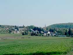
Felsőcsatár is a village in Vas County, Hungary.
Location
The nearest villages are Narda, Vaskeresztes, Torony, Dozmat and Nárai in Hungary, and Burg in Burgenland, Austria.
This article is issued from Wikipedia. The text is available under the Creative Commons Attribution/Share Alike; additional terms may apply for the media files.