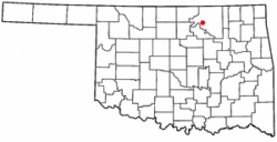
Fairfax, Oklahoma
| Fairfax, Oklahoma | |
|---|---|
| Town | |
 | |
| Coordinates: 36°34′17″N 96°42′23″W / 36.57139°N 96.70639°WCoordinates: 36°34′17″N 96°42′23″W / 36.57139°N 96.70639°W | |
| Country | United States |
| State | Oklahoma |
| County | Osage |
| Area | |
| • Total | 0.8 sq mi (2.1 km2) |
| • Land | 0.8 sq mi (2.1 km2) |
| • Water | 0.0 sq mi (0.0 km2) |
| Elevation | 853 ft (260 m) |
| Population (2010) | |
| • Total | 1,380 |
| • Density | 1,947.2/sq mi (751.8/km2) |
| Time zone | Central (CST) (UTC-6) |
| • Summer (DST) | CDT (UTC-5) |
| ZIP code | 74637 |
| Area code(s) | 539/918 |
| FIPS code | 40-24850[1] |
| GNIS feature ID | 1092690[2] |
Fairfax is a town in Osage County, Oklahoma, United States. The population was 1,380 at the 2010 census, down 11.3 percent from 1,555 at the 2000 census.[3]
History
The town of Fairfax began in 1903, when the Santa Fe Railroad built a line through the Osage Reservation from Kaw City, Oklahoma to Ralston, Oklahoma, and bypassed the existing Osage village of Gray Horse. A Gray Horse merchant, Lew A. Wismeyer, persuaded railroad officials to build a depot near the village and leased forty acres for a townsite. Wismeyer rejected the name Coda proposed by the railroad and convinced them to call the depot Fairfax. The Osage tribe retained title to the townsite until March 3, 1905, when Congress provided for the land to be sold at public auction, with the proceeds credited to the tribe.[4]
Geography
Fairfax is located at 36°34′17″N 96°42′23″W / 36.57139°N 96.70639°W (36.571386, -96.706259).[5]
According to the United States Census Bureau, the town has a total area of 0.8 square miles (2.1 km2), all of it land.
Climate
| Climate data for Fairfax, Oklahoma | |||||||||||||
|---|---|---|---|---|---|---|---|---|---|---|---|---|---|
| Month | Jan | Feb | Mar | Apr | May | Jun | Jul | Aug | Sep | Oct | Nov | Dec | Year |
| Average high °F (°C) | 46.6 (8.1) |
52.4 (11.3) |
62.9 (17.2) |
73.8 (23.2) |
80.8 (27.1) |
88.4 (31.3) |
94.4 (34.7) |
93.6 (34.2) |
85.2 (29.6) |
75.3 (24.1) |
61.2 (16.2) |
49.6 (9.8) |
72.02 (22.23) |
| Average low °F (°C) | 22.6 (−5.2) |
27.5 (−2.5) |
37.1 (2.8) |
47.9 (8.8) |
56.7 (13.7) |
65.3 (18.5) |
69.3 (20.7) |
67.5 (19.7) |
60.2 (15.7) |
47.8 (8.8) |
36.9 (2.7) |
26.2 (−3.2) |
47.08 (8.38) |
| Precipitation inches (mm) | 1.2 (30) |
1.6 (41) |
3.1 (79) |
3.2 (81) |
4.8 (122) |
4.2 (107) |
2.9 (74) |
3.3 (84) |
4.7 (119) |
2.9 (74) |
2.5 (64) |
1.6 (41) |
35.8 (909) |
| Source #1: weather.com | |||||||||||||
| Source #2: Weatherbase.com [6] | |||||||||||||
Demographics
As of the census[1] of 2000, there were 1,555 people, 657 households, and 417 families residing in the town. The population density was 1,947.2 people per square mile (750.5/km²). There were 831 housing units at an average density of 1,040.6 per square mile (401.1/km²). The racial makeup of the town was 67.65% White, 1.35% African American, 24.12% Native American, 0.19% Asian, 0.45% from other races, and 6.24% from two or more races. Hispanic or Latino of any race were 1.48% of the population.
There were 657 households out of which 30.3% had children under the age of 18 living with them, 43.4% were married couples living together, 15.8% had a female householder with no husband present, and 36.4% were non-families. 33.5% of all households were made up of individuals and 17.8% had someone living alone who was 65 years of age or older. The average household size was 2.31 and the average family size was 2.92.
In the town the population was spread out with 27.6% under the age of 18, 7.0% from 18 to 24, 22.6% from 25 to 44, 21.0% from 45 to 64, and 21.8% who were 65 years of age or older. The median age was 40 years. For every 100 females there were 83.8 males. For every 100 females age 18 and over, there were 78.2 males.
The median income for a household in the town was $21,652, and the median income for a family was $25,385. Males had a median income of $26,518 versus $21,250 for females. The per capita income for the town was $12,765. About 23.9% of families and 28.0% of the population were below the poverty line, including 38.8% of those under age 18 and 21.7% of those age 65 or over.
Notable people
- Maria Tallchief, professional ballerina
References
- ↑ 1.0 1.1 "American FactFinder". United States Census Bureau. Retrieved 2008-01-31.
- ↑ "US Board on Geographic Names". United States Geological Survey. 2007-10-25. Retrieved 2008-01-31.
- ↑ MuniNet Guide: Fairfax, Oklahoma
- ↑ Irons, Carol E. Encyclopedia of Oklahoma History and Culture. "Fairfax. Retrieved October 3, 2011. Fairfax had 470 residents at the time of statehood in 1907.
- ↑ "US Gazetteer files: 2010, 2000, and 1990". United States Census Bureau. 2011-02-12. Retrieved 2011-04-23.
- ↑ "Historical Weather for Fairfax, Oklahoma, United States".
External links
| ||||||||||||||||||||||
| |||||||||||||||||||||||

