Fahrenkrug
From Wikipedia, the free encyclopedia
| Fahrenkrug | ||
|---|---|---|
| ||
 Fahrenkrug | ||
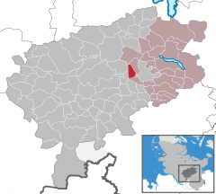
Location of Fahrenkrug within Segeberg district 
 | ||
| Coordinates: 53°56′N 10°15′E / 53.933°N 10.250°ECoordinates: 53°56′N 10°15′E / 53.933°N 10.250°E | ||
| Country | Germany | |
| State | Schleswig-Holstein | |
| District | Segeberg | |
| Municipal assoc. | Trave-Land | |
| Government | ||
| • Mayor | Rolf Studt (CDU) | |
| Area | ||
| • Total | 6.62 km2 (2.56 sq mi) | |
| Elevation | 27 m (89 ft) | |
| Population (2012-12-31)[1] | ||
| • Total | 1,542 | |
| • Density | 230/km2 (600/sq mi) | |
| Time zone | CET/CEST (UTC+1/+2) | |
| Postal codes | 23795 | |
| Dialling codes | 04551 | |
| Vehicle registration | SE | |
| Website |
www.amt-trave- land.de | |
Fahrenkrug is a municipality in the district of Segeberg, in Schleswig-Holstein, Germany. The two little villages Rotenhahn and Ziegelei belong also to Fahrenkrug. In the year 1192 has Varencroch, the old name of Fahrenkrug, been mentioned. In this text Varencroch was addicted to the monastery of Bad Segeberg. The name Varencroch means fern and corner, so that in the blazon of Fahrenkrug there are a fern and a corner.
In the prehistory of Fahrenkrug there settled humans. Next to stone axes and tools from the Stone Age, there was found significant finds in barrows Bronze Age, for example a golden ring, which .
References
- ↑ "Statistikamt Nord – Bevölkerung der Gemeinden in Schleswig-Holstein 4. Quartal 2012] (XLS-Datei) (Fortschreibung auf Basis des Zensus 2011)". Statistisches Amt für Hamburg und Schleswig-Holstein (in German). 25 July 2013.
This article is issued from Wikipedia. The text is available under the Creative Commons Attribution/Share Alike; additional terms may apply for the media files.
