Eus
From Wikipedia, the free encyclopedia
| Eus | |
|---|---|
 | |
 Eus | |
|
Location within Languedoc-Roussillon region  Eus | |
| Coordinates: 42°38′40″N 2°27′29″E / 42.6444°N 2.4581°ECoordinates: 42°38′40″N 2°27′29″E / 42.6444°N 2.4581°E | |
| Country | France |
| Region | Languedoc-Roussillon |
| Department | Pyrénées-Orientales |
| Arrondissement | Prades |
| Canton | Prades |
| Government | |
| • Mayor (2001–2008) | André Brugat |
| Area | |
| • Land1 | 20.08 km2 (7.75 sq mi) |
| Population (2006) | |
| • Population2 | 411 |
| • Population2 Density | 20/km2 (53/sq mi) |
| INSEE/Postal code | 66074 / 66500 |
| Elevation |
244–1,143 m (801–3,750 ft) (avg. 349 m or 1,145 ft) |
|
1 French Land Register data, which excludes lakes, ponds, glaciers > 1 km² (0.386 sq mi or 247 acres) and river estuaries. 2 Population without double counting: residents of multiple communes (e.g., students and military personnel) only counted once. | |
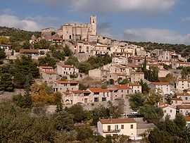
Eus is a commune in the Pyrénées-Orientales department in southern France.
See also
References
| Wikimedia Commons has media related to Eus. |
This article is issued from Wikipedia. The text is available under the Creative Commons Attribution/Share Alike; additional terms may apply for the media files.