European route E40
From Wikipedia, the free encyclopedia
| |
|---|---|
 | |
 E40 interchange near Bruges, Belgium | |
| Route information | |
| Length: | 8,500 km (5,300 mi) |
| Major junctions | |
| From: | E15 Calais (France) |
|
E17 Ghent (Belgium) E25 Liège (Belgium) E35 Cologne (Germany) E36 Bolesławiec (Poland) E45 Kirchheim (Germany) E55 Dresden (Germany) E65 Legnica (Poland) E75 Myslowice/Gliwice (Poland) E85 Dubno (Ukraine) E95 Kiev (Ukraine) E105 Kharkiv (Ukraine) E50 Debaltseve (Ukraine) E119 Astrakhan (Russia) E123 Tashkent (Uzbekistan) E125 Almaty (Kazakhstan) | |
| To: | Ridder (Kazakhstan) |
| Location | |
| Countries: | France, Belgium, Germany, Poland, Ukraine, Russia, Kazakhstan, Uzbekistan, Turkmenistan, Kyrgyzstan |
| Highway system | |
| International E-road network | |


E 40 roadsign in Skołoszów, Poland
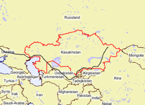
E 40 in Eastern Europe and Asia
European route E 40 is the longest European route,[1] more than 8,000 kilometres (4,971 miles) long, connecting Calais in France via Belgium, Germany, Poland, Ukraine, Russia, Kazakhstan, Uzbekistan, Turkmenistan, and Kyrgyzstan, with Ridder in Kazakhstan near the border to China.
Route
The route passes through:
- France: Calais - Dunkerque
- Belgium: Adinkerke - Veurne - Bruges - Ghent - Brussels - Leuven - Liège - Eupen
- Germany: Aachen - Cologne - Gummersbach - Olpe - Siegen - Wetzlar - Giessen - Bad Hersfeld - Herleshausen - Eisenach - Gotha - Erfurt - Weimar - Jena - Gera - Chemnitz - Dresden - Bautzen - Görlitz
- Poland: Zgorzelec - Legnica - Wrocław - Opole - Gliwice - Katowice - Jaworzno - Kraków - Tarnów - Rzeszów - Korczowa
- Ukraine: L'viv - Dubno - Rivne - Zhytomyr - Kiev - Lubny - Poltava - Kharkiv - Slovyansk - Debaltseve - Luhans'k
- Russia: Kamensk-Shakhtinsky - Volgograd[1] - Astrakhan' (Russian route M21 and Russian route M6)
- Kazakhstan: Atyrau - Beyneu
- Uzbekistan: Kungrad - Nukus
- Turkmenistan: Daşoguz
- Uzbekistan: Buchara - Samarkand - Jizzakh - Tashkent
- Kazakhstan: Shymkent - Taraz
- Kyrgyzstan: Bishkek
- Kazakhstan: Korday - Almaty - Sary-Ozek - Taldykorgan - Usharal - Taskesken - Ayagoz - Georgiyevka - Öskemen - Ridder
The road makes a big detour in Central Asia. The shortest road between Calais and Ridder is about 2,000 kilometres (1,243 miles) shorter, mostly using the E30 via Berlin-Moscow-Omsk.
Local numbering
The E40 coincides with the following national roads:
- France:
 Calais - Dunkirk (border)
- Belgium:
- Germany:
 Eynatten (border) - Aachen
 Aachen - Olpe
 Olpe - Wetzlar
 Wetzlar - Giessen
 Giessen
 Giessen - Reiskirchen
 Reiskirchen - Hattenbach
 Hattenbach - Kirchheim
- Kirchheim - Görlitz (border)
- Poland:
- Ukraine:
- Russia:
- Kazakhstan, Uzbekistan, Turkmenistan, Uzbekistan, Kazakhstan, Kyrgyzstan, and Kazakhstan:
External links
Gallery


.jpg)


References
Notes
| Wikimedia Commons has media related to E 40. |

This article is issued from Wikipedia. The text is available under the Creative Commons Attribution/Share Alike; additional terms may apply for the media files.