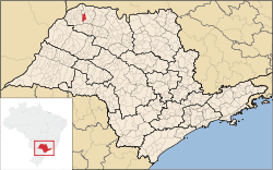
Estrela d'Oeste
| Estrela d'Oeste | ||
|---|---|---|
| Municipality | ||
| The Municipality of Estrela d'Oeste | ||
| ||
 | ||
| Coordinates: 20°17′16″S 50°24′03″W / 20.28778°S 50.40083°WCoordinates: 20°17′16″S 50°24′03″W / 20.28778°S 50.40083°W | ||
| Country |
| |
| Region | Southeast | |
| State |
| |
| Area | ||
| • Total | 296.4 km2 (114.4 sq mi) | |
| Elevation | 595 m (1,952 ft) | |
| Population (2010/IBGE) | ||
| • Total | 8,208 | |
| • Density | 27.7/km2 (72/sq mi) | |
| Time zone | UTC-3 (UTC-3) | |
| • Summer (DST) | UTC-2 (UTC-2) | |
| Postal Code | 15650-000 | |
| Area code(s) | +55 17 | |
| Website | Prefecture of Estrela d'Oeste | |
Estrela d'Oeste is a municipality in the state of São Paulo, Brazil. The city has a population of 8,208 inhabitants and an area of 296.4 km².[1]
Estrela d'Oeste belongs to the Mesoregion of São José do Rio Preto.
History
Estrela d´Oeste was founded at the beginning of the century.
It was named in the mid-1938 by Mariano Rodrigues. Previously belonged to Fernandópolis which in turn was named Vila Pereira.
Mariano Rodrigues added D'Oeste the village then known by all Star. The choice was made by means of a draw between three options.
The first mayor of the city was José Antonio Saes, 'Ze firefight', son of John Saes presented and supported by its founder Mariano Rodrigues, his cousin.
Demography
'Census Data - 2010'
Total Population: 8208
- Urban: 6831
- Rural: 1377
- Men: 4133[2]
- Women: 4075
Population density (inhab. / Km ²): 27.69
Census Data - 2000
- Infant mortality to 1 year (per thousand): 10.43
- Life expectancy (years): 74.42
- Fertility rate (children per woman): 1.96
- Literacy Rate: 87.26%
- Human Development Index (HDI): 0.792
- Income HDI: 0.705
- HDI Longevity: 0.824
- HDI Education: 0.848
(Source: IPEADATA)
References
- ↑ "2010 Census of the IBGE - Population - Table 2.1.20" (in Portuguese). IBGE.gov.br. Retrieved 12 June 2012.
- ↑ "SIDRA IBGE - Table 608 - Resident population, by household status and sex". IBGE. Retrieved 11 December 2012.
| ||||||||||||||||||||||||||||||||||||||||||||||||||||||||||||||||
