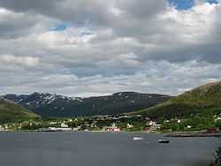
Ersfjordbotn
From Wikipedia, the free encyclopedia
| Ersfjordbotn | |
|---|---|
| Village | |
 | |
 Ersfjordbotn | |
| Coordinates: 69°41′38″N 18°36′18″E / 69.69389°N 18.60500°ECoordinates: 69°41′38″N 18°36′18″E / 69.69389°N 18.60500°E | |
| Country | Norway |
| Region | Northern Norway |
| County | Troms |
| District | Midt-Troms |
| Municipality | Tromsø |
| Area[1] | |
| • Total | 0.33 km2 (0.13 sq mi) |
| Elevation[2] | 0.5 m (1.6 ft) |
| Population (2012)[1] | |
| • Total | 353 |
| • Density | 1,070/km2 (2,800/sq mi) |
| Time zone | CET (UTC+01:00) |
| • Summer (DST) | CEST (UTC+02:00) |
| Post Code | 9107 Kvaløya |

View of Ersfjorden in the winter, up behind the village of Ersfjordbotn (Dec 2012)
Ersfjordbotn is a village at the end of the Ersfjorden on the island of Kvaløya in the municipality of Tromsø in Troms county, Norway. The village sits on an isthmus between the Ersfjorden and the Kaldfjorden, about 15 kilometres (9.3 mi) west of the city of Tromsø. The villages of Kjosen and Kvaløysletta are located just to the east of Ersfjordbotn.[3]
Ersfjordbotn is slowly moving from a traditional rural settlement to a suburb of Tromsø, and most people work in Tromsø, half an hour's drive away. The 0.33-square-kilometre (82-acre) village has a population (2012) of 353, which gives the village a population density of 1,070 inhabitants per square kilometre (2,800 /sq mi).[1]
References
- ↑ 1.0 1.1 1.2 Statistisk sentralbyrå (1 January 2012). "Urban settlements. Population and area, by municipality.".
- ↑ "Ersfjordbotn" (in Norwegian). yr.no. Retrieved 2012-12-14.
- ↑ Store norske leksikon. "Ersfjordbotn" (in Norwegian). Retrieved 2012-12-14.
This article is issued from Wikipedia. The text is available under the Creative Commons Attribution/Share Alike; additional terms may apply for the media files.